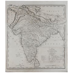
Original Antique Map of India, circa 1820
View Similar Items


Want more images or videos?
Request additional images or videos from the seller
1 of 5
Original Antique Map of India, circa 1820
About the Item
- Dimensions:Height: 12 in (30.48 cm)Width: 10 in (25.4 cm)Depth: 0.07 in (1.78 mm)
- Style:Other (In the Style Of)
- Materials and Techniques:Paper,Other
- Place of Origin:
- Period:
- Date of Manufacture:1820
- Condition:Wear consistent with age and use.
- Seller Location:St Annes, GB
- Reference Number:1stDibs: LU1836321871052
About the Seller
4.9
Platinum Seller
These expertly vetted sellers are 1stDibs' most experienced sellers and are rated highest by our customers.
1stDibs seller since 2016
2,531 sales on 1stDibs
Associations
International Confederation of Art and Antique Dealers' Associations
More From This SellerView All
- Original Antique Map of France, Arrowsmith, 1820Located in St Annes, LancashireGreat map of France Drawn under the direction of Arrowsmith. Copper-plate engraving. Published by Longman, Hurst, Rees, Orme and Brown, 1820 Unframed.Category
Antique 1820s English Maps
MaterialsPaper

- Original Antique Map of Hungary, Arrowsmith, 1820Located in St Annes, LancashireGreat map of Hungary Drawn under the direction of Arrowsmith. Copper-plate engraving. Published by Longman, Hurst, Rees, Orme and Brown, 1820 Unframed.Category
Antique 1820s English Maps
MaterialsPaper

- Original Antique Map of China, Arrowsmith, 1820Located in St Annes, LancashireGreat map of China Drawn under the direction of Arrowsmith Copper-plate engraving Published by Longman, Hurst, Rees, Orme and Brown, 1820 Unfr...Category
Antique 1820s English Maps
MaterialsPaper

- Original Antique Map of Canada, Arrowsmith, 1820Located in St Annes, LancashireGreat map of Canada. Drawn under the direction of Arrowsmith. Copper-plate engraving. Published by Longman, Hurst, Rees, Orme and Brown, 1820 ...Category
Antique 1820s English Maps
MaterialsPaper

- Original Antique Map of Europe, Arrowsmith, 1820Located in St Annes, LancashireGreat map of Europe Drawn under the direction of Arrowsmith. Copper-plate engraving. Published by Longman, Hurst, Rees, Orme and Brown, 1820 ...Category
Antique 1820s English Maps
MaterialsPaper

- Original Antique Map of Italy. Arrowsmith. 1820Located in St Annes, LancashireGreat map of Italy Drawn under the direction of Arrowsmith Copper-plate engraving Published by Longman, Hurst, Rees, Orme and Brown, 1820 Unframed.Category
Antique 1820s English Maps
MaterialsPaper

You May Also Like
- Original Antique Map of Northern IndiaBy Jakob van der SchleyLocated in Langweer, NLAntique map titled 'Carte de l'Indoustan (..) - Kaart van Hindoestan (..)'. Original antique map of northern India. This map originates from 'His...Category
Antique Mid-18th Century Maps
MaterialsPaper
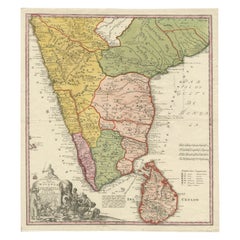
- Original Antique Map of Malabar, Coromandel 'India' and CeylonLocated in Langweer, NLAntique map titled 'Peninsula Indiae citra Gangem, hoc est Orae celeberrimae Malabar & Coromandel (..)'. Large and attractive original hand colored map of Sri Lanka and the Southern ...Category
Antique Mid-18th Century Maps
MaterialsPaper
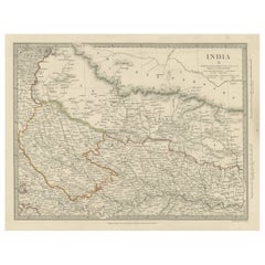
- Original Antique Map of Part of the Bahar Region (India), 1834Located in Langweer, NLAntique map titled 'India X'. Old steel engraved map of part of the Bahar region, it also shows part of Nepal. Artists and Engravers: Engraved by J. & C. Walker. Published under th...Category
Antique 19th Century Maps
MaterialsPaper
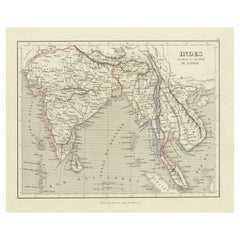
- Antique Map of India to Southeast AsiaLocated in Langweer, NLAntique map titled 'Indes en-decà et au-delà du Gange'. Original old map of India to Southeast Asia, showing India, Nepal, Bhutan, Sri Lanka (Ceylon), Myanmar (Birma), part of Indone...Category
Antique Mid-19th Century Maps
MaterialsPaper
- Antique Map of Asia by Brué '1820'Located in Langweer, NLAntique map titled 'Carte de l'Asie'. Original antique map of Asia. A blind stamp near the title reads 'Carte Encyprotipe'. This map originates fro...Category
Antique Early 19th Century Maps
MaterialsPaper
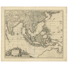
- Antique Map of Southeast Asia 'India, Indonesia' by N. Visscher, circa 1670Located in Langweer, NLAntique map titled 'Indiae Orientalis, nec non Insularum Adiacentium Nova Descriptio.' The map centers on the Strait of Malacca and Malay Peninsula. It extends from India and the Mal...Category
Antique Mid-17th Century Maps
MaterialsPaper
 $1,692 Sale Price20% Off