Items Similar to Antique Map of France by Faden '1792'


Want more images or videos?
Request additional images or videos from the seller
1 of 6
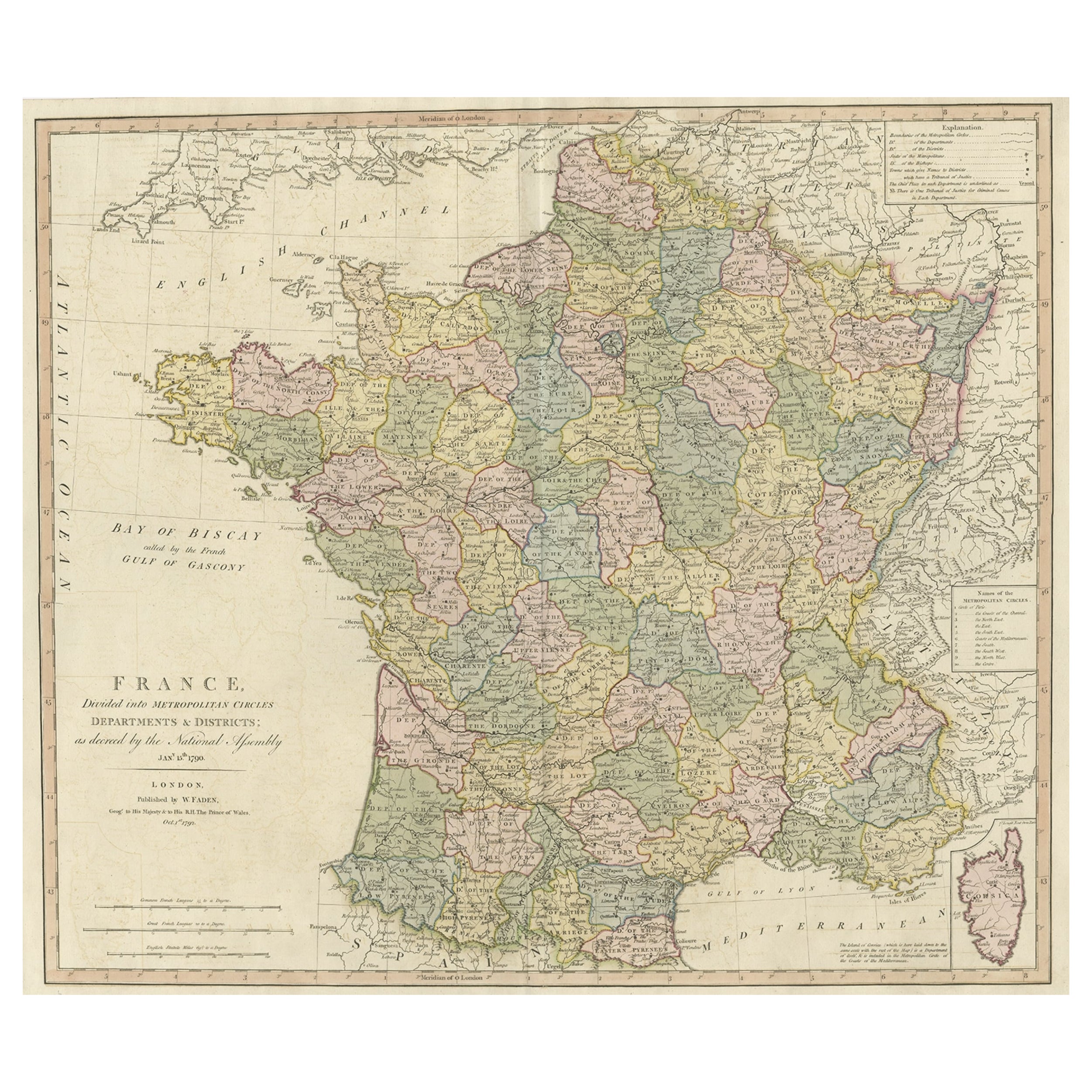
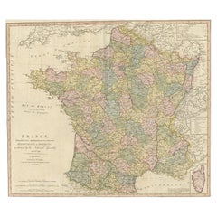
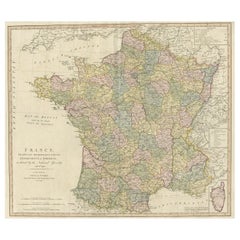
Antique Map of France by Faden '1792'
About the Item
Antique map titled 'France divided into Metropolitan Circles (..)'. Large, original antique map of France, with a small inset of the island of Corsica. Published by W. Faden, 1792.
- Dimensions:Height: 23.23 in (59 cm)Width: 31.5 in (80 cm)Depth: 0.02 in (0.5 mm)
- Materials and Techniques:
- Period:
- Date of Manufacture:1792
- Condition:General age-related toning. Original/contemporary coloring, original folding line. Minor wear, blank verso. Please study images carefully.
- Seller Location:Langweer, NL
- Reference Number:
About the Seller
5.0
Platinum Seller
These expertly vetted sellers are 1stDibs' most experienced sellers and are rated highest by our customers.
Established in 2009
1stDibs seller since 2017
1,909 sales on 1stDibs
Typical response time: <1 hour
- ShippingRetrieving quote...Ships From: Langweer, Netherlands
- Return PolicyA return for this item may be initiated within 14 days of delivery.
More From This SellerView All
- Antique Map of France by Faden, 1792Located in Langweer, NLAntique map titled 'France divided into Metropolitan Circles (..)'. Large, original antique map of France, with a small inset of the island of Co...Category
Antique 18th Century Maps
MaterialsPaper
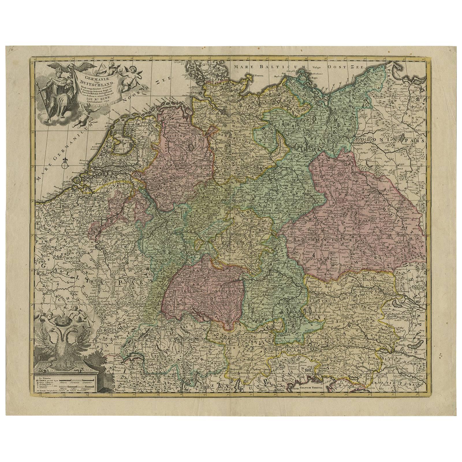
- Antique Map of Germany by J.B. Elwe, 1792Located in Langweer, NLAntique map titled 'Germanie vulgo Duitschland (..)'. Decorative map of Germany with Silesia, Bohemia , Netherlands, Belgium, Elzas, Switzerland, Tyrol and Austria. With two cartouch...Category
Antique Late 18th Century Maps
MaterialsPaper
- Original Hand-Colored Antique Map of Africa by Elwe '1792'Located in Langweer, NLAntique map titled 'l'Afrique Divisée en ses Empires, Royaumes, et Etats'. Decorative large map of Africa. The cartography is typical for the 17th century with the Nile originating i...Category
Antique Late 18th Century Maps
MaterialsPaper
- Large Antique Map of France, with a Small Inset of the Island of Corsica, 1792Located in Langweer, NLAntique map titled 'France divided into Metropolitan Circles (..)'. Large, original antique map of France, with a small inset of the island of Corsica. Published by W. Faden, 179...Category
Antique 1790s Maps
MaterialsPaper
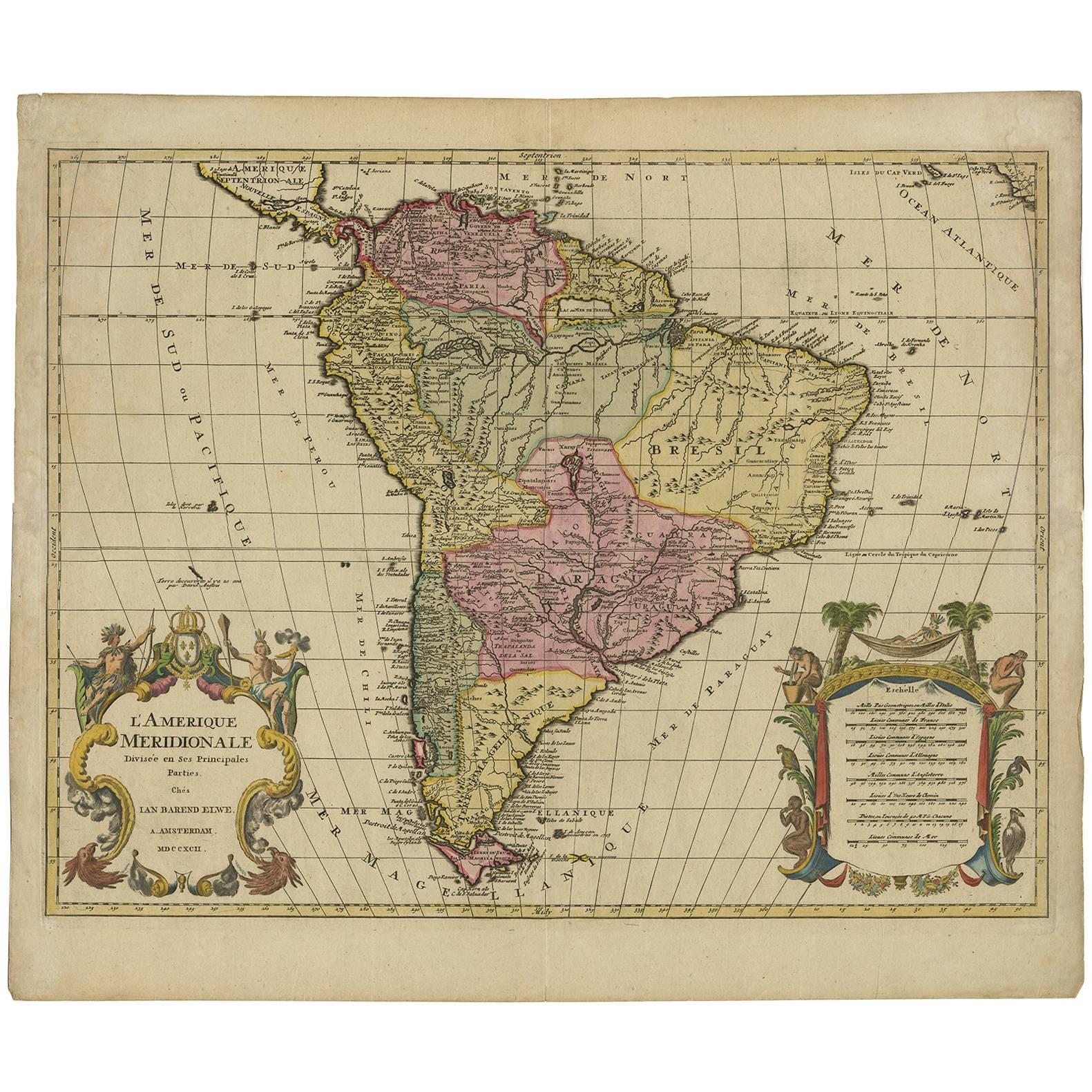
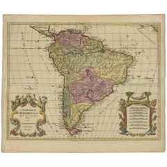
- Decorative Original HandColoredAntique Map of South America by J.B. Elwe, 1792By J.B. ElweLocated in Langweer, NLThis image depicts 'L'Amerique Meridionale', an antique map of South America. The map is carefully hand-colored, showcasing the diverse countries within the continent, including Braz...Category
Antique Late 18th Century Maps
MaterialsPaper
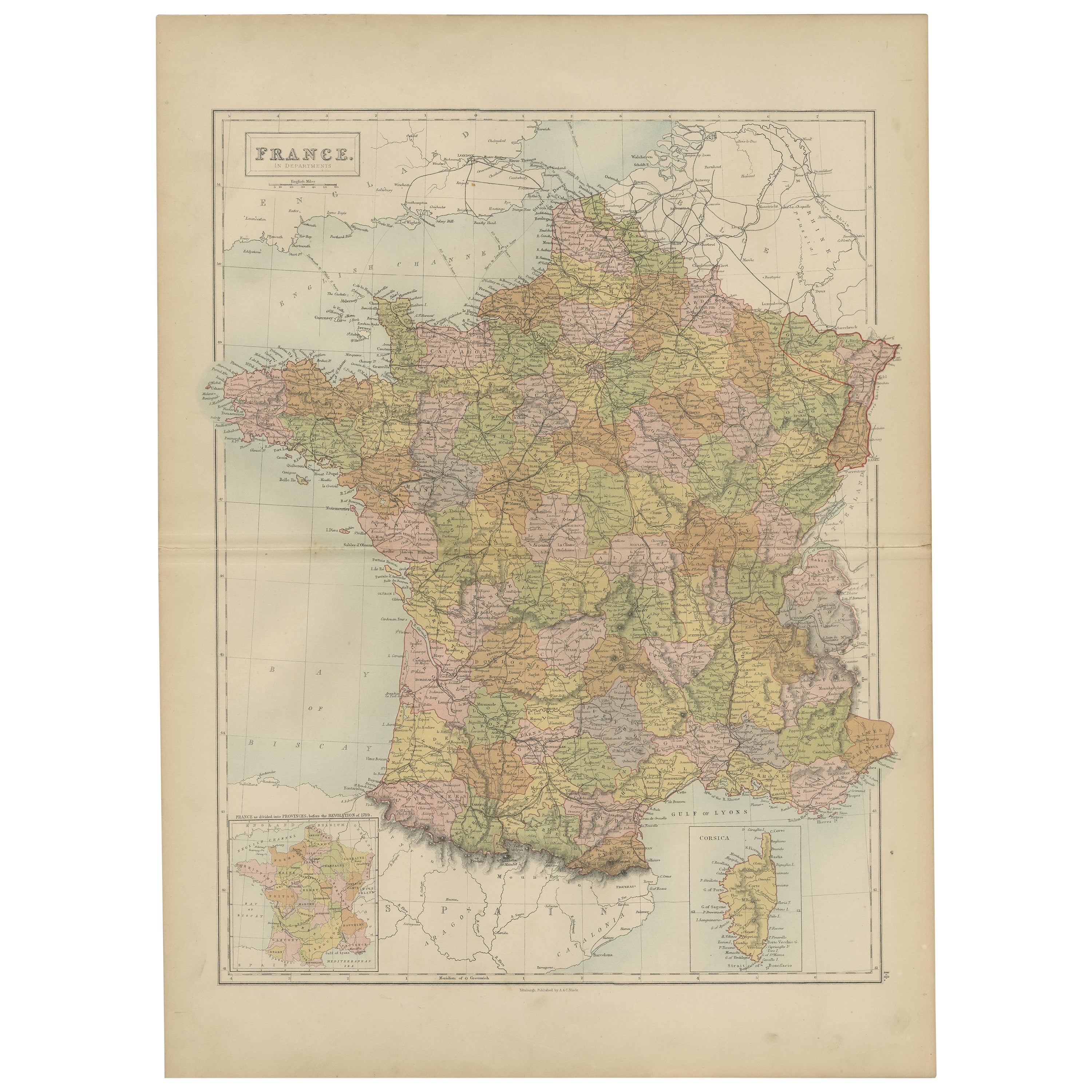
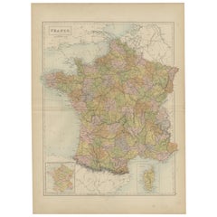
- Antique Map of France by A & C. Black, 1870Located in Langweer, NLAntique map titled 'France'. Original antique map of France with inset map of France as divided into provinces, before the revolution of 1789 and map of Corsica...Category
Antique Late 19th Century Maps
MaterialsPaper


You May Also Like
- Original Antique Map of France, Arrowsmith, 1820Located in St Annes, LancashireGreat map of France Drawn under the direction of Arrowsmith. Copper-plate engraving. Published by Longman, Hurst, Rees, Orme and Brown, 1820 Unframed.Category
Antique 1820s English Maps
MaterialsPaper
- Antique Map of Italy by Andriveau-Goujon, 1843By Andriveau-GoujonLocated in New York, NYAntique Map of Italy by Andriveau-Goujon, 1843. Map of Italy in two parts by Andriveau-Goujon for the Library of Prince Carini at Palazzo Carini i...Category
Antique 1840s French Maps
MaterialsLinen, Paper
- Antique Map of Principality of MonacoBy Antonio Vallardi EditoreLocated in Alessandria, PiemonteST/619 - "Old Geographical Atlas of Italy - Topographic map of ex-Principality of Monaco" - ediz Vallardi - Milano - A somewhat special edition ---Category
Antique Late 19th Century Italian Other Prints
MaterialsPaper
- Original Antique Map of Russia By Arrowsmith. 1820Located in St Annes, LancashireGreat map of Russia Drawn under the direction of Arrowsmith Copper-plate engraving Published by Longman, Hurst, Rees, Orme and Brown, 1820 Unframed.Category
Antique 1820s English Maps
MaterialsPaper
- Original Antique Map of France, Sherwood, Neely & Jones, Dated 1809Located in St Annes, LancashireGreat map of France Copper-plate engraving by Cooper Published by Sherwood, Neely & Jones. Dated 1809 Unframed.Category
Antique Early 1800s English Maps
MaterialsPaper
- Original Antique Map of China by Thomas Clerk, 1817Located in St Annes, LancashireGreat map of China Copper-plate engraving Drawn and engraved by Thomas Clerk, Edinburgh. Published by Mackenzie And Dent, 1817 Unframed.Category
Antique 1810s English Maps
MaterialsPaper


Recently Viewed
View AllMore Ways To Browse
Antique Large Island
French Antique Island
Antique Large Maps
Antique French Divider
Antique French 18th Century Map
Antique Map Engraving
Antique City Map
Antique City Maps
Antique Maps Of Cities
England Map
Antique World Maps And Atlases World Maps
Antique Furniture Portugal
Map Of England
Original City Map
Antique Furniture Edinburgh
Maps Colored
Antique Map Of Holland
Antique Furniture Mexico