Items Similar to Antique Map of British Guayana with Insets of Georgetown, Devil's Rock Etc, 1851


Want more images or videos?
Request additional images or videos from the seller
1 of 5
Antique Map of British Guayana with Insets of Georgetown, Devil's Rock Etc, 1851
About the Item
Antique map titled ‘British Guayana’. Includes decorative vignettes titled Georgetown, Christmas Cataract River Berbice, New Amsterdam and Ataraipu or the Devil’s Rock. Originates from 'The Illustrated Atlas, And Modern History Of The World Geographical, Political, Commercial & Statistical, Edited By R. Montgomery Martin'. Published; John Tallis London, New York, Edinburgh & Dublin. 1851. Drawn and Engraved by J. Rapkin.
Artists and Engravers: John Tallis (1817-1876) was a British map publisher. Born in the Midlands, Tallis came to London in the 1840s. Tallis began his London career with a series of remarkable London street views. He began a partnership with a Frederick Tallis, possibly his brother, but their collaboration ended in 1849. For the Great Exhibition of 1851, Tallis published the Illustrated World Atlas, one of the last series of decorative world maps ever produced. The maps were engraved by John Rapkin, a skilled artisan. The maps were later reissued by the London Printing & Publishing Company, who left the Tallis imprint intact, thus ensuring his enduring fame. In 1858, he began publication of the popular Illustrated News of the World and National Portrait Gallery of Eminent Personages, selling it in 1861 (it ceased publication in 1863).
We sell original antique maps to collectors, historians, educators and interior decorators all over the world. Our collection includes a wide range of authentic antique maps from the 16th to the 20th centuries. Buying and collecting antique maps is a tradition that goes back hundreds of years. Antique maps have proved a richly rewarding investment over the past decade, thanks to a growing appreciation of their unique historical appeal. Today the decorative qualities of antique maps are widely recognized by interior designers who appreciate their beauty and design flexibility. Depending on the individual map, presentation, and context, a rare or antique map can be modern, traditional, abstract, figurative, serious or whimsical. We offer a wide range of authentic antique maps for any budget.
- Dimensions:Height: 14.18 in (36 cm)Width: 10.83 in (27.5 cm)Depth: 0 in (0.01 mm)
- Materials and Techniques:
- Period:
- Date of Manufacture:1851
- Condition:Condition: Good. General age-related toning. Original fold as published, small tears along the folding line and page border. Please study image carefully.
- Seller Location:Langweer, NL
- Reference Number:
About the Seller
5.0
Platinum Seller
These expertly vetted sellers are 1stDibs' most experienced sellers and are rated highest by our customers.
Established in 2009
1stDibs seller since 2017
Typical response time: <1 hour
- ShippingRetrieving quote...Ships From: Langweer, Netherlands
- Return PolicyA return for this item may be initiated within 14 days of delivery.
More From This SellerView All
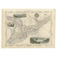
- Beautiful Decorative Hand-Colored Antique Map of West Canada, 1851Located in Langweer, NLDescription: Antique map of Canada titled 'West Canada'. With decorative vignettes titled Kingston and Falls of Niagara. Originates from 'The Illustrated Atlas, And Modern History Of The World Geographical, Political, Commercial & Statistical, Edited By R. Montgomery Martin'. Published; John Tallis London, New York, Edinburgh & Dublin. 1851. Drawn and Engraved by J. Rapkin. Artists and Engravers: John Tallis (1817-1876) was a British map...Category
Antique 1850s Maps
MaterialsPaper
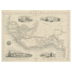
- Antique Map of Western Africa with Vignettes of Cape Coast Castle etc, ca.1851Located in Langweer, NLAntique map titled ‘Western Africa’. Includes decorative vignettes titled Christiansborg, Cape Coast Castle, Sierra Leone and Bakel. Originates from 'The Illustrated Atlas, And Modern History Of The World Geographical, Political, Commercial & Statistical, Edited By R. Montgomery Martin'. Published; John Tallis London, New York, Edinburgh & Dublin. 1851. Drawn and Engraved by J. Rapkin. Artists and Engravers: John Tallis (1817-1876) was a British map...Category
Antique 1850s Maps
MaterialsPaper
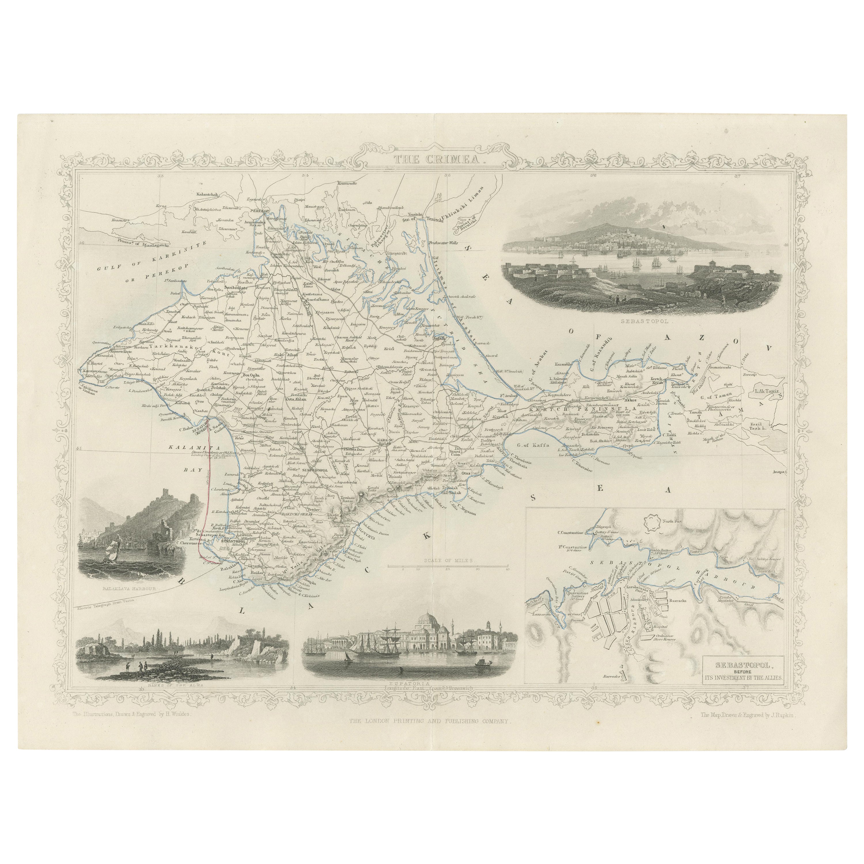
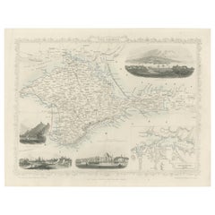
- A Decorative Detailed Map of the Crimea, with an Inset Map of Sebastopol, c 1851Located in Langweer, NLDate: 1851 Artist and Engraver: J Rapkin Vingettes: Artist and Engraver: H. Winkles Paper Size: 350 x 270mms Condition: good Technique: original steel engraving Description: ...Category
Antique 1850s Maps
MaterialsPaper
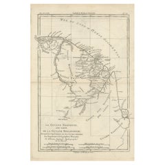
- Antique Map of South America Depicting Guayana, c.1780Located in Langweer, NLAntique map titled 'La Guyane Francopise avec partie de la Guyane Hollandoise: suivant les Operations et les Cartes recentes des Ingenieurs-Geographes Francois'. Antique map of South...Category
Antique 18th Century Maps
MaterialsPaper
- Antique Map of British India with Insets of Kabul and NepalLocated in Langweer, NLAntique map titled 'British India, northern part'. Large format map of the northern area of the Indian subcontinent. The map is engraved in the minimalist English style pioneered in ...Category
Antique Early 19th Century Maps
MaterialsPaper
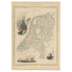
- Antique Map of Holland with Colorful Vignettes, 1851Located in Langweer, NLAntique map titled 'Holland'. Decorative map of Holland. Includes vignettes of Rotterdam, Dutch Peasants and a boating scene on the Dort, the Netherlands. Originates from 'Th...Category
Antique 19th Century Maps
MaterialsPaper

You May Also Like
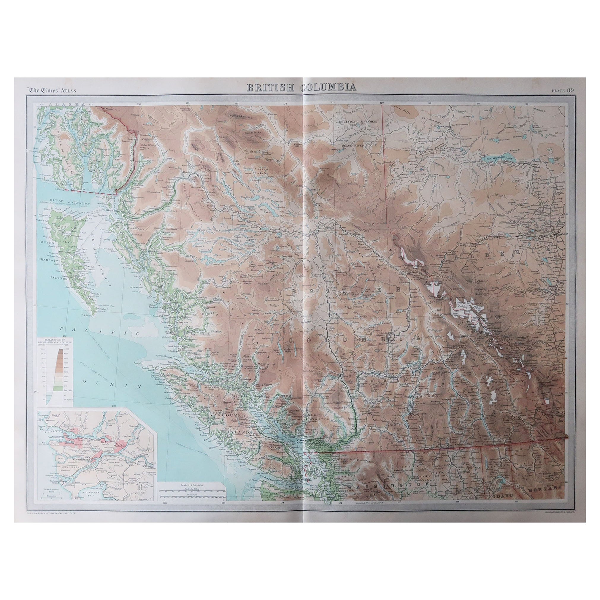
- Large Original Vintage Map of British Columbia, Canada, circa 1920Located in St Annes, LancashireGreat map of British Columbia Unframed Original color By John Bartholomew and Co. Edinburgh Geographical Institute Published, circa 1920 ...Category
Vintage 1920s British Maps
MaterialsPaper
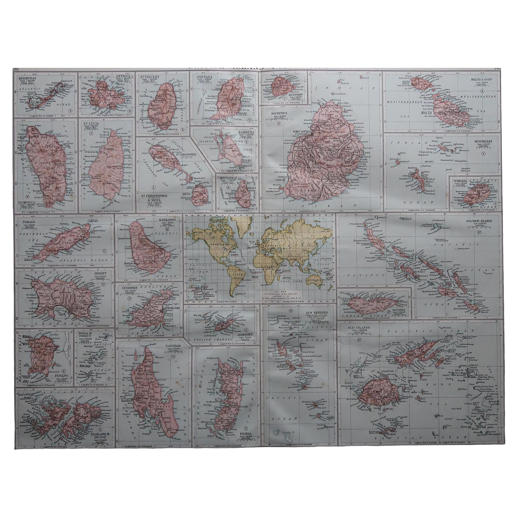
- Large Original Vintage Map of British Island Possessions, circa 1920Located in St Annes, LancashireGreat map of British Island Possessions Original color. Good condition Published by Alexander Gross Unframed.Category
Vintage 1920s English Maps
MaterialsPaper
- Original Antique Map of Missouri, 1889Located in St Annes, LancashireGreat map of Missouri Drawn and Engraved by W. & A.K. Johnston Published By A & C Black, Edinburgh. Original colour Unframed.Category
Antique 1880s Scottish Victorian Maps
MaterialsPaper

- Original Antique Map of Indonesia, 1861Located in St Annes, LancashireGreat map of Indonesia Drawn and engraved by Edward Weller Original color Published in The Weekly Dispatch Atlas, 1861 Repairs to minor e...Category
Antique 1860s English Victorian Maps
MaterialsPaper

- Original Antique Map of Cyprus. Circa 1880Located in St Annes, LancashireGreat map of Cyprus Drawn and Engraved by R.Walker Published W.Mackenzie, London Original colour Unframed.Category
Antique 1880s English Maps
MaterialsPaper
- Large Original Antique Map of Australia, Fullarton, C.1870Located in St Annes, LancashireGreat map of Australia From the celebrated Royal Illustrated Atlas Engraved by Swanston after the drawing by Augustus Petermann Lithograph. Original color. Published by ...Category
Antique 1870s Scottish Maps
MaterialsPaper


Recently Viewed
View AllMore Ways To Browse
Antique Etc
Map York
Antique Exhibition Quality
Britain Map
Map Of Britain
Antique And Artisan Gallery
Antique Artisan Gallery
Devil Furniture
19th Century Christmas
Antique Map Border
Antique British Maps
Antique Maps Of Britain
Antique New York Map
Antique Map New York
Antique New York Maps
Antique Maps New York
New York Antique Map
Antique Maps Of New York