Items Similar to Antique Map of Southern Sweden by Covens & Mortier, 'circa 1720'


Want more images or videos?
Request additional images or videos from the seller
1 of 5
Antique Map of Southern Sweden by Covens & Mortier, 'circa 1720'
About the Item
Antique map titled 'Regni Gothiae (..)'. Detailed map of South Sweden. Embellished with beautiful title cartouche with scale and coats of arms. Published in Amsterdam by Covens & Mortier, circa 1720.
- Dimensions:Height: 21.07 in (53.5 cm)Width: 25.4 in (64.5 cm)Depth: 0.02 in (0.5 mm)
- Materials and Techniques:
- Period:
- Date of Manufacture:circa 1720
- Condition:Beautiful original/contemporary hand coloring. Great condition. General age-related toning, original folding line. Blank verso. Please study images carefully.
- Seller Location:Langweer, NL
- Reference Number:
About the Seller
5.0
Platinum Seller
These expertly vetted sellers are 1stDibs' most experienced sellers and are rated highest by our customers.
Established in 2009
1stDibs seller since 2017
1,909 sales on 1stDibs
Typical response time: <1 hour
- ShippingRetrieving quote...Ships From: Langweer, Netherlands
- Return PolicyA return for this item may be initiated within 14 days of delivery.
More From This SellerView All
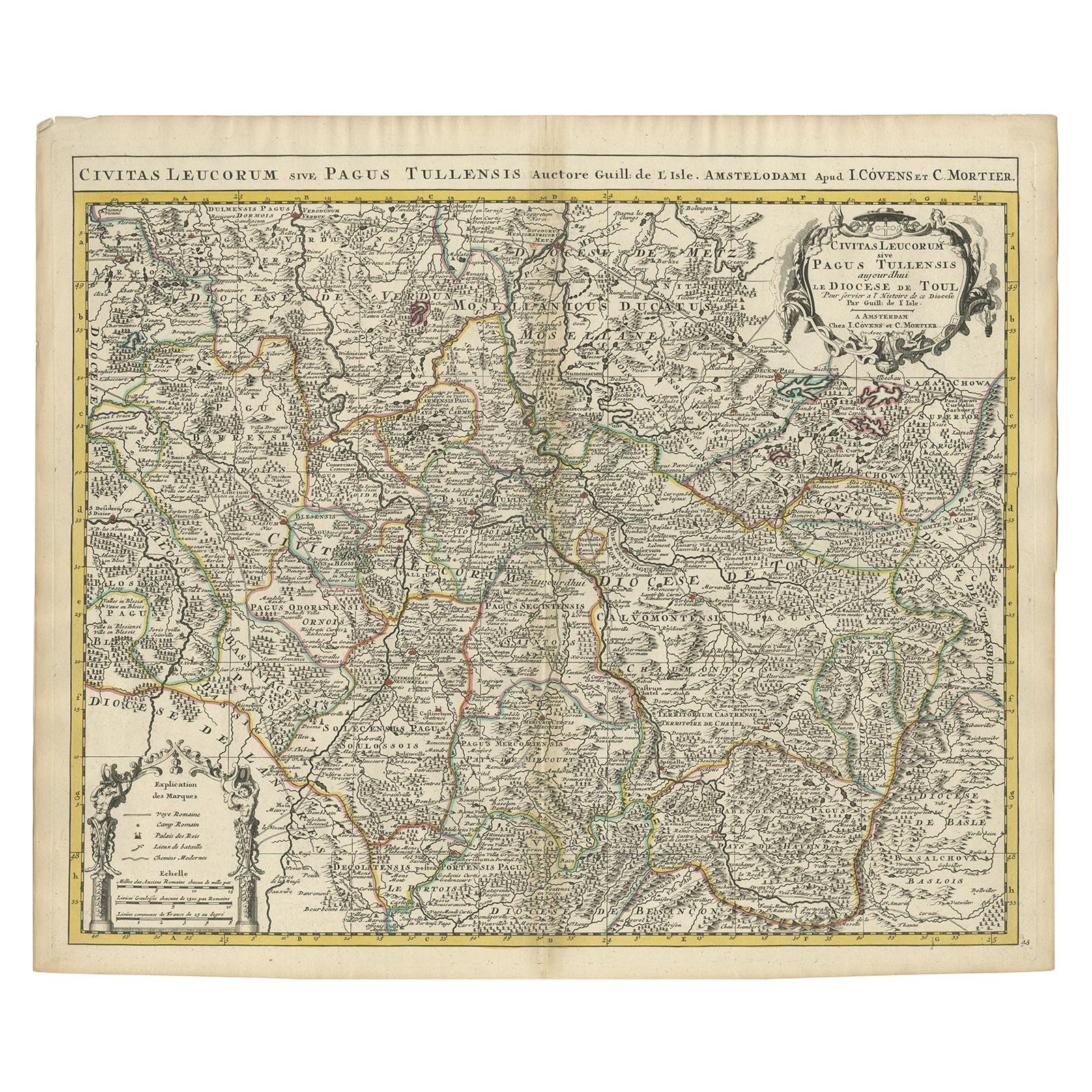
- Antique Map of the Diocese of Toul by Covens & Mortier, circa 1720By Covens & MortierLocated in Langweer, NLAntique map titled 'Civitas Leucorum sive Pagus Tullensis'. Detailed map of the Diocese of Toul, France. Centered on the cities of Nancy and Toul and including Metz, Verdun, S. Dizie...Category
Antique Early 18th Century Maps
MaterialsPaper
- Antique Map of Denmark by Covens & Mortier, 1730By Covens & MortierLocated in Langweer, NLAntique Map of Denmark from: 'Atlas Nouveau ... Par Guillaume de l'Isle' Amsterdam, Covens & Mortier, 1730.Category
Antique Mid-18th Century Maps
MaterialsPaper
- Antique Map of Western Russia by Covens & Mortier, 1740Located in Langweer, NLAntique map titled 'Carte de Moscovie'. Antique map of the western portion of Russia. The map centers on Moscow (shown near the top of the lower sheet) and spans from the Sea of Azov...Category
Antique Mid-18th Century Maps
MaterialsPaper
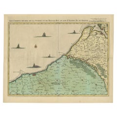
- Antique Map of the French Coast by Covens & Mortier, 1720Located in Langweer, NLAntique map France titled 'Les Embouchures de la Somme et de Bresle Riv. ou est St. Valeri, Eu et Dieppe'. Beautiful map of the French coast, from St. Valeri to Dieppe. Artists a...Category
Antique 18th Century Maps
MaterialsPaper
- Antique Bible Plan of Jerusalem by Covens & Mortier, 1743Located in Langweer, NLThis plan originates from ‘Biblia Sacra, dat is, de H. Schriftuer van het Oude, en het Nieuwe Testament, naer de laetste Roomsche keure der gemeine Latijnsche overzettinge, in nederd...Category
Antique Mid-18th Century Maps
MaterialsPaper
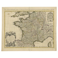
- Antique Map of France by Covens & Mortier, c.1730Located in Langweer, NLAntique map titled 'Nova regni Galliae (..) La France'. Old map of France with large decorative title cartouche. With great detail. Artists and Engravers: Pieter und David Mortie...Category
Antique 18th Century Maps
MaterialsPaper


You May Also Like
- Original Antique Map of Sweden, Engraved by Barlow, 1806Located in St Annes, LancashireGreat map of Sweden Copper-plate engraving by Barlow Published by Brightly & Kinnersly, Bungay, Suffolk. 1806 Unframed.Category
Antique Early 1800s English Maps
MaterialsPaper
- Original Antique Map of Belgium by Tallis, Circa 1850Located in St Annes, LancashireGreat map of Belgium Steel engraving Many lovely vignettes Published by London Printing & Publishing Co. ( Formerly Tallis ), C.1850 Origin...Category
Antique 1850s English Maps
MaterialsPaper
- Original Antique Map of South America, circa 1830Located in St Annes, LancashireGreat map of South America Copper plate engraving Published by Butterworth, Livesey & Co., circa 1830 Unframed.Category
Antique Early 1800s English Other Maps
MaterialsPaper
- Original Antique Map of South East Asia by Becker, circa 1840Located in St Annes, LancashireGreat map of South East Asia Steel engraving with original color outline Engraved by Becker Published by Virtue, circa 1840. Unframed.Category
Antique 1840s English Other Maps
MaterialsPaper
- Original Antique Map / City Plan of Brussels by Tallis, circa 1850Located in St Annes, LancashireGreat map of Brussels. Steel engraving. Published by London Printing & Publishing Co. (Formerly Tallis), C.1850 Free shipping.Category
Antique 1850s English Maps
MaterialsPaper
- Original Antique Map of Spain and Portugal, circa 1790Located in St Annes, LancashireSuper map of Spain and Portugal Copper plate engraving by A. Bell Published, circa 1790. Unframed.Category
Antique 1790s English Other Maps
MaterialsPaper


Recently Viewed
View AllMore Ways To Browse
Southern Antique Furniture
Antique Southern Furniture
Southern Antiques
Scale Map
Antique Maps Amsterdam
Amsterdam Map
18th Century Southern Antiques
Amsterdam Coat Of Arms
Map Of Sweden
Mortier Antique
Map Sweden
Sweden Antique Map
Map Plate
Island Maps
Antique Map Of France
Antique Maps Of France
Antique Historical Maps
16th Century World Map