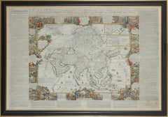
Important giant Map of Asia, for the King of France, 1696
View Similar Items


Want more images or videos?
Request additional images or videos from the seller
1 of 4
Nicolas de FerImportant giant Map of Asia, for the King of France, 16961698
1698
About the Item
- Creator:Nicolas de Fer (1646 - 1720, French)
- Creation Year:1698
- Dimensions:Height: 43.12 in (109.5 cm)Width: 64.18 in (163 cm)
- Medium:
- Movement & Style:
- Period:Late 17th Century
- Framing:Frame IncludedFraming Options Available
- Condition:
- Gallery Location:Amsterdam, NL
- Reference Number:1stDibs: LU147128029142
About the Seller
No Reviews Yet
Vetted Seller
These experienced sellers undergo a comprehensive evaluation by our team of in-house experts.
1stDibs seller since 2021
Typical response time: 1 hour
More From This SellerView All
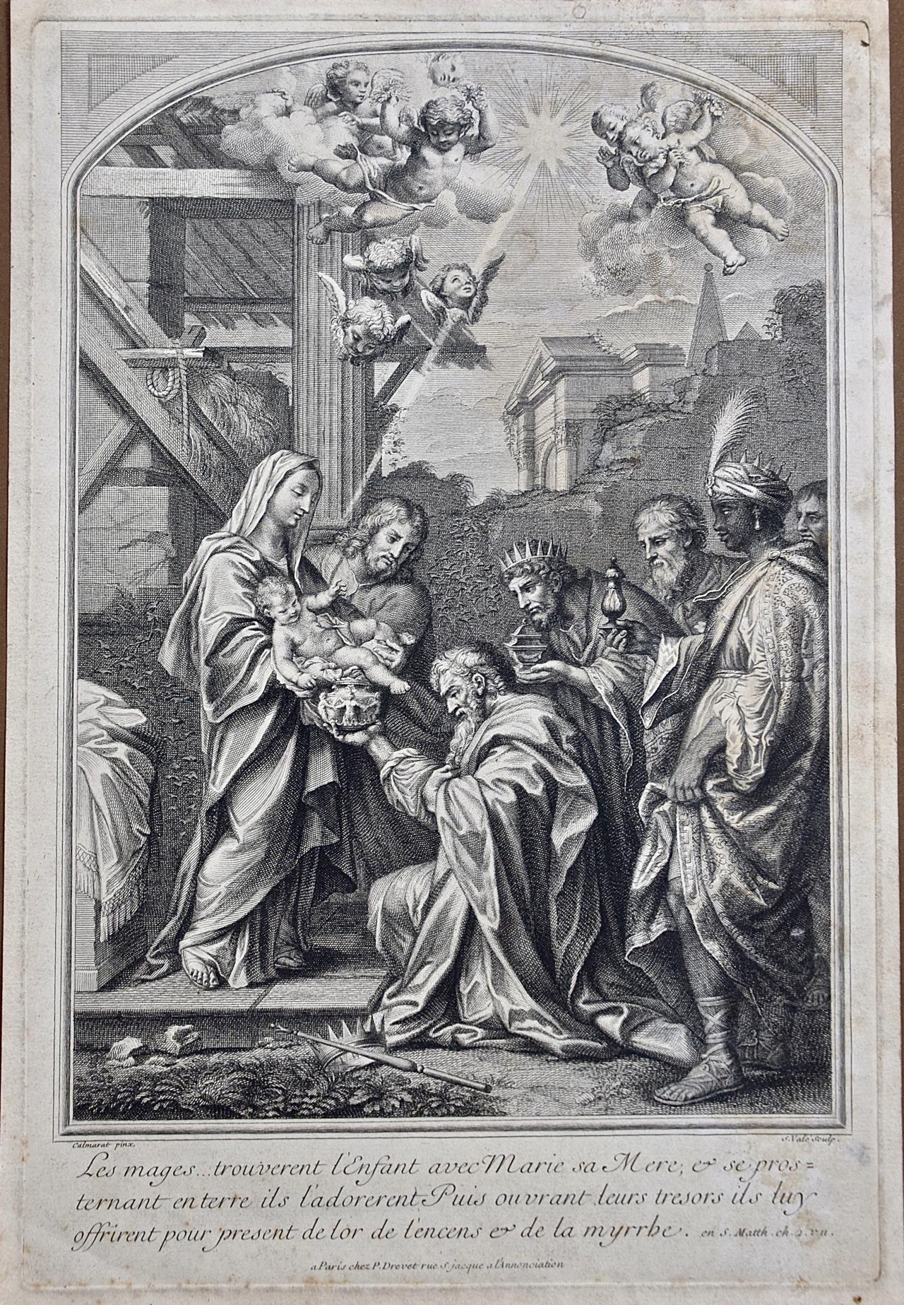
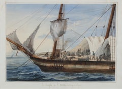
- Portrait of a Slave Ship: 'Le Negrito à l’ancre. Dans le port de la havanne'Located in Amsterdam, NLFRANÇOIS MATHURIN ADALBERT, BARON DE COURCY (1805-1839) 'Le Negrito à l’ancre. Dans le port de la havanne' Indistinctly signed lower left Titled on the mount Pencil and watercolour, heightened with white, on paper, 24.8 x 34.6 cm Literature: The present watercolour will be illustrated in: - Prof. Manuel Garcia’s projected book on the disease and the slave trade provisionally titled “Fighting the Yellow Demon of Fever: The Struggle against Disease in the Illegal Slave Trade”. - Prof. Micael Zeuske’s forthcoming Global history of slave trade. Exhibited: Mexico City, 1998, Palacio Virreinal, El Barón de Courcy, illustrationes de un viaje, 1831-1833, no. 108 Note: Baron de Courcy was in the Caribbean in late 1832 and early 1833, following his tour of Mexico in 1832, on the last leg of his “Grand Voyage...Category
Mid-19th Century Old Masters Figurative Drawings and Watercolors
MaterialsGouache, Pencil, Paper, Watercolor
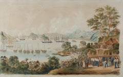
- 1854 Funeral of R. Williams at Gyokusen-ji Temple, Shimoda, with Commodore PerryLocated in Amsterdam, NLWilhelm Heine (Dresden 30 January 1827-Löbnitz 5 October 1885) ‘Funeral of Robert Williams in the cemetery of the Temple Gyokusen-ji at Shimoda in April 1854’ With a sticker on the reverse of the frame by Coupil & Co. 1855 Watercolour on paper, H. 57 x W. 92 cm Depicted is the Bay of Shimoda with seven American ships including the two paddle-wheel warships USS Mississippi and Susquehanna. On the Gyokus- en-ji temple grounds on the right is the coffin in the middle with the remains of US marine Robert Williams, ready to be lowered into the grave. Looking on from the left are the Buddhist monks and Japanese officials who joined the first Christian funeral on Japanese soil. Around the grave are US marines, Commodore Perry...Category
Mid-19th Century Figurative Drawings and Watercolors
MaterialsPaper, Ink, Watercolor, Gouache
 Price Upon RequestFree Shipping
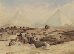
 - Devotion in the Dessert near the pyramids of Gizeh, circa 1919By Marius BauerLocated in Amsterdam, NLMarius Bauer (1867-1932) ‘Devotie in de Woestijn’ (Devotion in the Dessert near the pyramids of Gizeh, circa 1919) Signed lower right and titled lower left Watercolour on paper, H...Category
Early 20th Century Impressionist Landscape Drawings and Watercolors
MaterialsPaper, Ink, Watercolor, Pencil
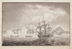
- Naval Battle between British and Dutch ships at Batavia, Indonesia, 1806Located in Amsterdam, NLEdward Proudfoot Montagu (1791-1862) ‘The representation of HMS Caroline Cap(tain) P(eter) Rainer attacking a Dutch Squadron in Batavia Roads on the 18th of October 1806’ Signed wi...Category
Early 19th Century Romantic Landscape Drawings and Watercolors
MaterialsInk, Watercolor, Paper
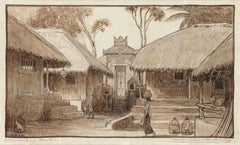
- Village Northern Bali, 1906Located in Amsterdam, NLPremises in North Bali, 1906 Signed with initials and titled bottom left and fully signed, bottom right Pencil and ink on paper, 10.5 x 18 cm Black ebonized frame with white mount ...Category
Early 1900s Art Nouveau Landscape Drawings and Watercolors
MaterialsPaper, Graphite
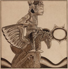
- Statue of Vishnu Garuda, Bali, 1904Located in Amsterdam, NLStatue of Vishnu Garuda, Bali, 1904 Signed with initials Pencil and ink on paper, 21.4 x 21.3 cm Literature: Bruce W. Carpenter, W.O.J. Nieuwenkamp. First European Artist in Bali,...Category
Early 1900s Art Nouveau Landscape Drawings and Watercolors
MaterialsPaper, Pencil, India Ink
You May Also Like
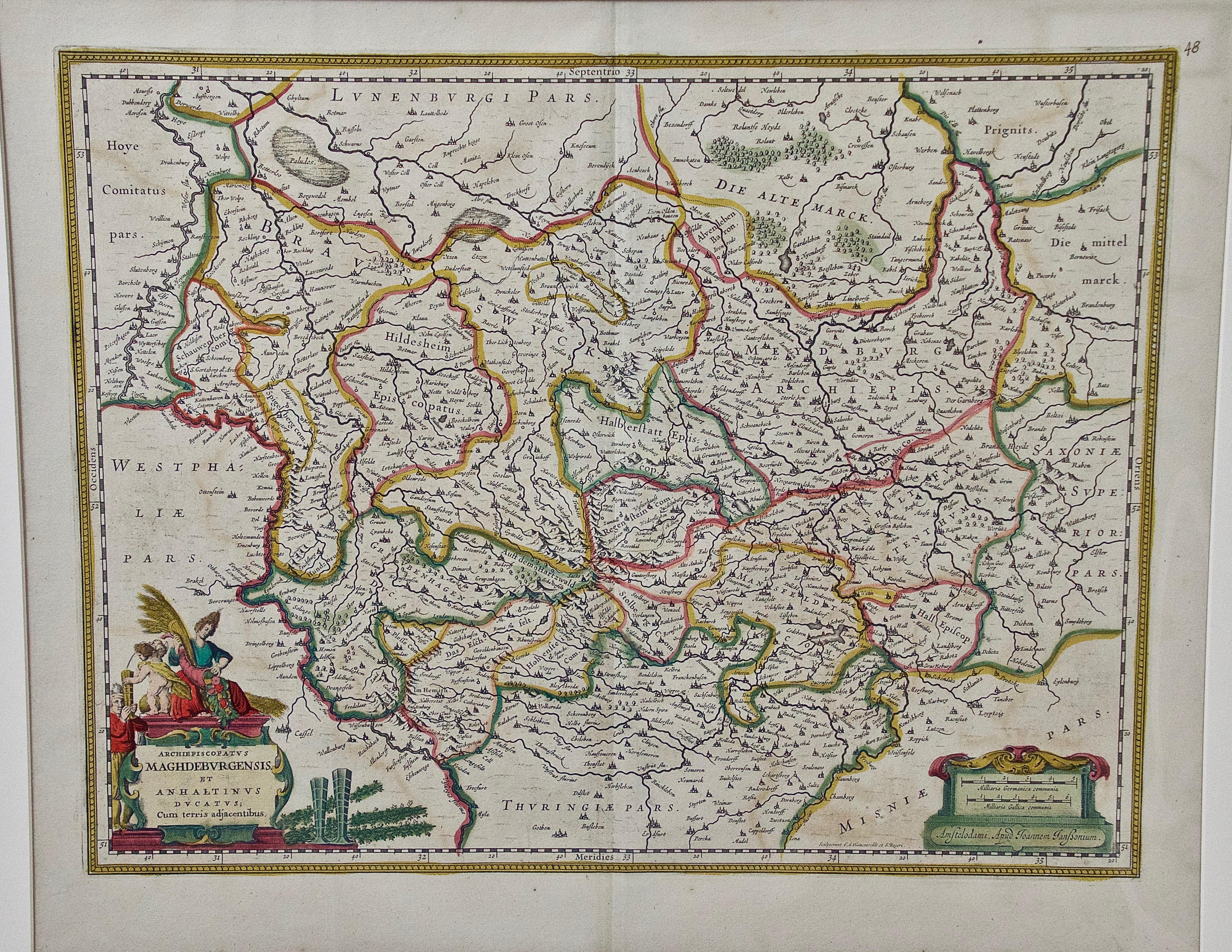
- West Germany: Original Hand Colored 17th Century Map by Johannes JanssoniusBy Johannes JanssoniusLocated in Alamo, CAAn original hand colored copperplate engraved map entitled in Latin "Archiepiscopatus Maghdeburgensis et Anhaltinus Ducatus cum terris adjacentibus", published in Amsterdam in 1640 i...Category
Mid-17th Century Old Masters More Prints
MaterialsEngraving
- Canterbury: An Original 16th C. Framed Hand-colored Map by Braun & HogenbergBy Franz HogenbergLocated in Alamo, CAThis is a framed 16th century map and city view of Canterbury, England entitled "Cantuarbury" by Braun & Hogenburg, from their famous landmark atlas of city views 'Civitates Orbis Terrarum' (Atlas of the Cities of the World), which was first published in Cologne, Germany in 1572. The map of Canterbury was first published in 1588. It depicts a detailed birdseye view of the completely walled and fortified city of Canterbury, with its cathedral the most prominent feature. The coat of arms of England, Canterbury, and the Archbishop of Canterbury are included. This beautifully hand-colored map is presented in a gold-colored wood frame with a beaded inner trim and a paprika-colored mat that highlights details in the map. The frame measures 18.75" high by 22.25" wide by 0.875" deep. There is a central vertical fold, as issued. The map is in excellent condition. Braun and Hogenberg's 'The Civitates Orbis Terrarum' was the second atlas of maps ever published and the first atlas of cities and towns of the world. It is one of the most important books published in the 16th century. Most of the maps in the atlas were engraved by Franz Hogenberg and the text, with its descriptions of the history and additional factual information of the cities, was written by a team of writers and edited by Georg Braun. The work contained 546 bird-eye views and map views of cities and towns from all over the world. It gave graphic representation of the main features of the illustrated cities and towns, including the buildings and streets. Although the ordinary buildings are stylized, the principal buildings are reproduced from actual drawings created on location. The principal landmarks and streets can still be recognized today. In addition, the maps often include the heraldic arms of the city, the nature of the surrounding countryside, the important rivers, streams and harbors, even depicting stone bridges, wooden pontoons, flat-bottomed ferries, ships and working boats, wharves and jetties, as well as land-based activities, including horsemen, pedestrians, wagons, coaches, and palanquins. Small vignettes are often included which illustrate the trade, occupations and habits of the local inhabitants, such as agriculture, paper-making and textiles, as well as local forms of punishment, such as gibbets, wheels, floggings etc. Large figures dressed in their local costume are often presented out of proportion in the foreground. The aim of the authors was to give as much information as possible in a pleasing visual form. They succeeded in creating maps that were both informative and decorative works of art. The atlas is a wonderful glimpse of life in medieval Europe. Georg Braun (1541-1622) was German Catholic...Category
16th Century Old Masters Landscape Prints
MaterialsEngraving
- View of Meissen, Germany: A 16th Century Hand-colored Map by Braun & HogenbergBy Franz HogenbergLocated in Alamo, CAThis is a 16th century original hand-colored copperplate engraved map of View of View of Meissen, Germany entitled "Misena Hermun Duvorum Urbs" by Georg Braun & Franz Hogenberg, from their famous city atlas "Civitates Orbis Terrarum", published in Cologne, Germany in 1575. The map depicts a side view and bird's-eye view, looking across the Elbe River (labelled Albis Fluvius on the map; White River in Latin) from the northeast. In the foreground are three women in conversation on a hill above the city, along with a man and a woman in conversation by a road, all dressed in contemporary costumes of the upper class. A coat-of-arms is present in each upper corner. A great castle sits atop a hill in the background on the left. Meissen grew up around Albrechtsburg castle, built by Emperor Henry I around AD 929, and was granted a municipal charter at the end of the 12th century. From 1471 onwards, the castle complex was reconstructed as the residence of the Saxon electors on the northeast corner of the Domberg (Cathedral Hill). Meissen cathedral is a Gothic hall church begun c. 1270; in 1413 a bolt of lightning destroyed its west towers, which were replaced only in the 20th century. Meissen lies to the northwest of Dresden, Germany in Saxony. Meissen is famous for its Meissen porcelain and the Albrechtsburg castle The following is an English translation of an excerpt from Braun's description of the city: "This city is surrounded by very many rivers, to the east flows the Elbe, to the south the Triebisch, to the west are the mountains, to the north the Meisse, after which the city is said to be named. The city is well-situated in its surroundings, the navigable rivers, the mountains and the healthy air. Around the city there is a good land to grow grain, fertile vineyards on the hillsides and without doubt the mountains are not without ore, for one mile away, up the Elbe, is Scharfenberg, where silver and lead ore are mined.." References: Van der Krogt 4, 2684; Taschen, Braun and Hogenberg...Category
16th Century Old Masters Landscape Prints
MaterialsEngraving
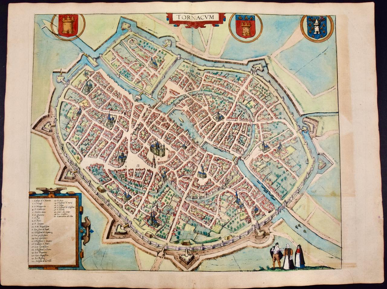
- Tournai (Tournay), Belgium: A 16th Century Hand-colored Map by Braun & HogenbergBy Franz HogenbergLocated in Alamo, CAThis is a 16th century original hand-colored copperplate engraved map of Tournai, Belgium, entitled "Tornacum" by Georg Braun & Franz Hogenberg, in volume IV of their famous city atlas "Civitates Orbis Terrarum", published in Cologne or Augsberg, Germany in 1575. The map provides a bird's-eye view of the walled city of Tournai, the second oldest city in Belgium. It lies approximately one hour by car southwest of Brussels or from Ghent. The names of thirty of its streets, prominent buildings, churches and squares are listed in a key within a strap-work cartouche in the lower left. These locations are numbered in the key corresponding to their locations on the map. This colorful map of Tournai (Tornacum or Tournay as it was called in the 16th century) includes the title in Latin in a cartouche in the upper center. Three crests are present across the upper map. A man and two woman are standing on a hill in the foreground in the lower right dressed in the style of 16th century upper class residents of the town. This is an English translation of an excerpt of Braun's description of Tornai: “Tornacum or Turnacum is a city in Gallia Belgica, situated on the Schelde in the territory of the Nervii, called Tournai by its French inhabitants, but Dorneck by the Germans. Tournai has always been a large and powerful city, with an abundance of goods and commercial activities and wonderfully resourceful craftsmen, who invent new articles every day, and although some of these go out of use they constantly conceive of other new things, both useful and delightful, so that they have at all times something that provides work and a means of livelihood for the poor." ReferencesVan der Krogt 4, 4435, State 1; Taschen, Braun and Hogenberg...Category
16th Century Old Masters Landscape Prints
MaterialsEngraving
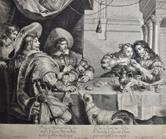
- The Card Game: An Early 17th Century Engraving by A. Voet after Cornelis de VosBy Alexander VoetLocated in Alamo, CAA 17th century engraving entitled "The Card Game" by old master artist Alexander de Voet after a painting by Cornelis de Vos, created in 1632. The pain...Category
1630s Old Masters Interior Prints
MaterialsEngraving
- Frankfort, Germany: A 16th Century Hand-colored Map by Braun & HogenbergBy Franz HogenbergLocated in Alamo, CAThis is a 16th century original hand-colored copperplate engraved map of Frankfort, Germany entitled "Francenbergum, vel ut alij Francoburgum Hassiae Opp" by Georg Braun & Franz Hogenberg, from their famous city atlas "Civitates Orbis Terrarum", published in Cologne, Germany in 1595. This is an English translation of an excerpt from the original text in the atlas: "Frankenberg or, according to others, Francoburgum, a town in Hesse. Charlemagne vested the town of Frankenberg with many freedoms and privileges, which it still enjoys to this day, and on account of its valiant and victorious soldiers awarded a signet, upon which there formerly appeared a golden castle with a tower, together with the letter F and a golden crown. Frankenberg, seen here from the northeast, lies on a hill above the River Eder. The hillside is covered with fields neatly separated by bushes and fences. Soaring above the town is the massive Liebfrauenkirche, which was modelled on St Elizabeth's church in Marburg. The New Town was founded in 1335 at the foot of the hill (right) and merged with the Old Town as late as 1556. Frankenberg was founded by Conrad of Thuringia in 1233/34 to prevent the archbishops of Mainz from expanding their sphere of influence...Category
16th Century Old Masters Landscape Prints
MaterialsEngraving