Items Similar to View of Venice, including Gondolas, 18th Century Hand Colored Engraving


Want more images or videos?
Request additional images or videos from the seller
1 of 11
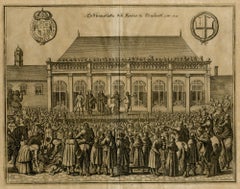
Pieter Van Der AaView of Venice, including Gondolas, 18th Century Hand Colored Engraving 1722
1722
About the Item
An early 18th century hand colored engraving of a scene of the city of Venice, Italy entitled "Palazzo Lin, a. S. Samuele sopra il Canal Grande". It depicts Venetian architecture, water commerce with gondolas and a sailboat. The engraving was published in "Thesaurus antiquitatum et historiarum Italiane" by Pieter van Der Aa (1659-1733) in Leiden. The book was originally written in the 17th century by Georgius Graevius and completed after his death by Pieter Burmann.
The print is framed in a gold carved wood frame with a taupe mat. There is a vertical fold, as issued. It is in very good condition.
- Creator:Pieter Van Der Aa (1659 - 1733, Dutch)
- Creation Year:1722
- Dimensions:Height: 18.5 in (46.99 cm)Width: 21 in (53.34 cm)Depth: 1.25 in (3.18 cm)
- Medium:
- Movement & Style:
- Period:1720-1729
- Condition:
- Gallery Location:Alamo, CA
- Reference Number:
About the Seller
5.0
Platinum Seller
These expertly vetted sellers are 1stDibs' most experienced sellers and are rated highest by our customers.
Established in 2011
1stDibs seller since 2019
228 sales on 1stDibs
Typical response time: 1 hour
- ShippingRetrieving quote...Ships From: Alamo, CA
- Return PolicyA return for this item may be initiated within 7 days of delivery.
More From This SellerView All
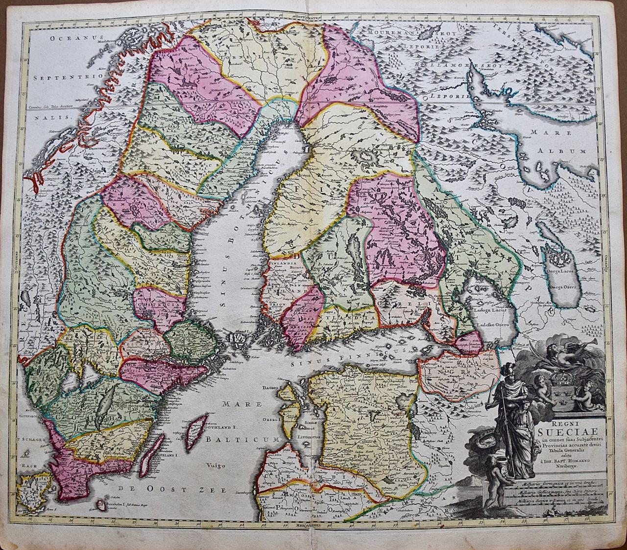
- Sweden and Adjacent Portions of Scandinavia: A Hand-colored 18th C. Homann MapBy Johann Baptist HomannLocated in Alamo, CAThis hand-colored copper-plate map of Sweden and adjacent portions of Scandinavia entitled "Regni Sueciae in Omnes suas Subjacentes Provincias accurate divisi Tabula Generalis" was c...Category
Early 18th Century Old Masters Landscape Prints
MaterialsEngraving
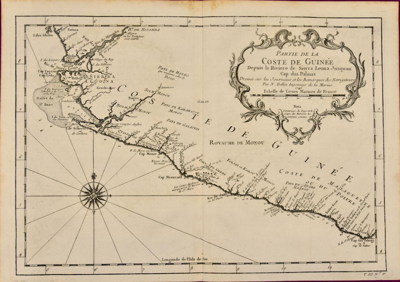
- West Coast of Africa; Guinea & Sierra Leone: Bellin 18th Century MapLocated in Alamo, CAThis is a Jacques Bellin copper-plate map entitled "Partie de la Coste de Guinee Dupuis la Riviere de Sierra Leona Jusquau Cap das Palmas", depicting the coast of Guinea and Sierra L...Category
1740s Old Masters Landscape Prints
MaterialsEngraving
- Danube River, Italy, Greece and Croatia: A Hand-colored 18th C. Homann MapBy Johann Baptist HomannLocated in Alamo, CA"Fluviorum in Europa principis Danubii" is a hand colored map of the region about the Danube river created by Johann Baptist Homann (1663-1724) in his 'Atlas Novus Terrarum', publish...Category
Early 18th Century Old Masters Landscape Prints
MaterialsEngraving
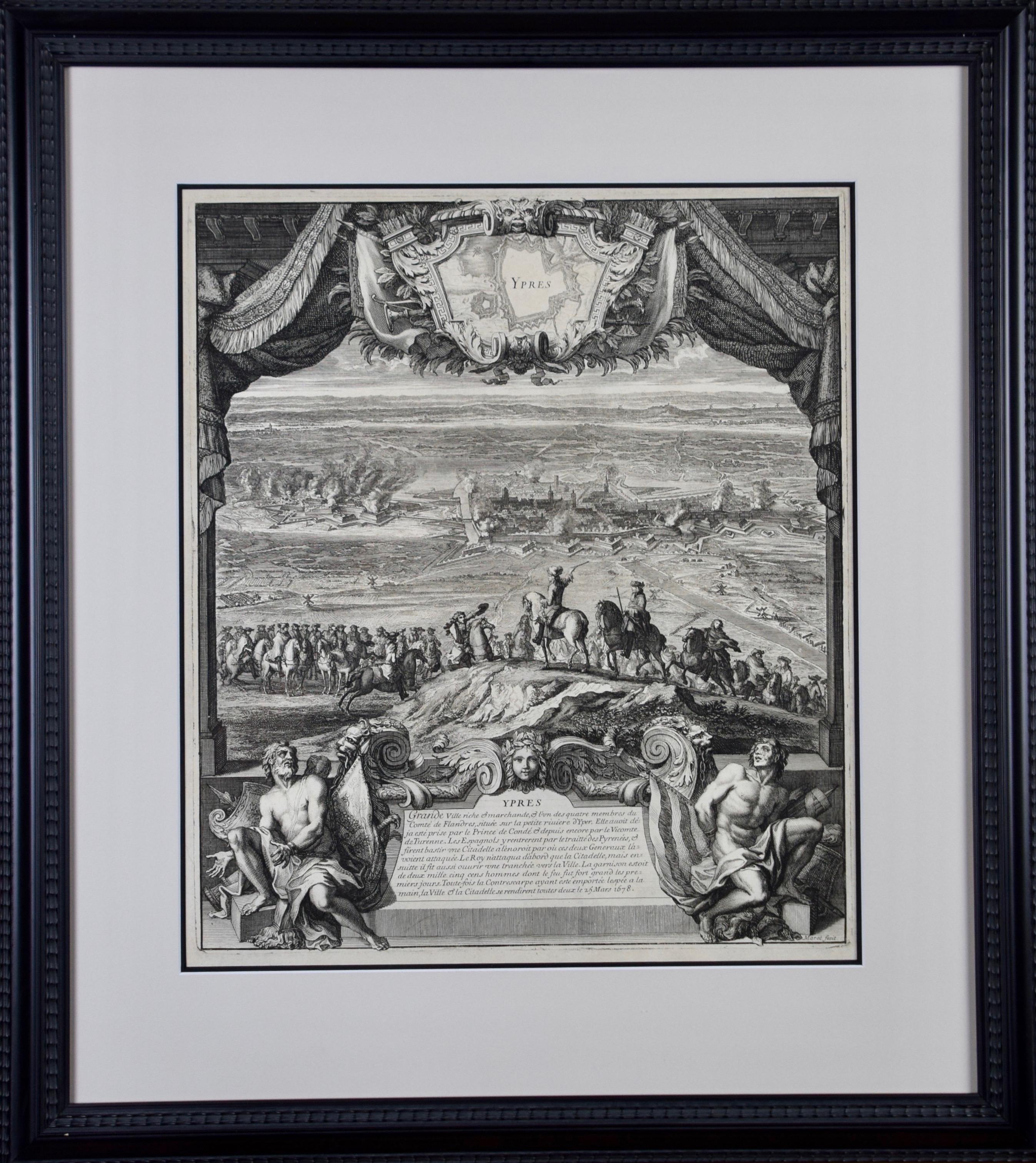
- Daniel Marot's The Siege of the Dutch Fortified City of Ypres by Louis XIVBy Daniel MarotLocated in Alamo, CA"Ypres, Grand Ville Riche & Marchande" is an engraving and etching by Daniel Marot (le Vieux) (1661–1752). It depicts a view of the siege of the city of Ypres and its citadel on the left in the Spanish Netherlands by Louis XIV's troops. This battle took place between March 18 and March 25, 1678, as part of the Franco-Dutch War. Marot illustrated in great detail (best appreciated with magnification) the French attack on the strong pentagonal citadel on the extreme left, which had been built recently in anticipation of a French attack. The trenches built by the French approaching the town are seen on the right. King Louis XIV can be seen in the foreground surveying the battle mounted on his white horse, surrounded by his officers and troops. The print is presented in an attractive ornate black wood frame with a cream-colored double mat with a black inner trim. It is glazed with plexiglas. The frame measures 25.38" x 22.63" x .88". The engraving, frame, mat and glazing are in excellent condition. Artist: Daniel Marot (1661–1752) was also called "Le Vieux". He was the son of the famous architect, Jean Marot. Marot had diverse interests and talents. In addition to his art, he designed garden projects, architectural ornaments, furniture, and even upholstery. Marot as a Huguenot protestant was forced to leave France in 1685 following the revocation of the Edict of Nantes. He emigrated to Holland, where he worked for William of Orange (an arch enemy of his former employer Louis XIV). Marot was largely responsible for the interiors of Williams palace at the Loo. In 1694 he went Britain as William had married Queen Mary and he had become King William III of England. He later returned to Holland in about 1698 and died in the Hague in 1752. He left a lasting legacy on the decorative arts in the Netherlands, where his grand version of the Louis XIV style remained popular into the 1730s. Historical Background: In October 1677, Mary Stuart, niece and possible successor of Charles II of England, married Louis XIV's arch enemy William III of Orange...Category
Late 17th Century Old Masters Landscape Prints
MaterialsEngraving, Etching
- Canterbury: An Original 16th C. Framed Hand-colored Map by Braun & HogenbergBy Franz HogenbergLocated in Alamo, CAThis is a framed 16th century map and city view of Canterbury, England entitled "Cantuarbury" by Braun & Hogenburg, from their famous landmark atlas of city views 'Civitates Orbis Terrarum' (Atlas of the Cities of the World), which was first published in Cologne, Germany in 1572. The map of Canterbury was first published in 1588. It depicts a detailed birdseye view of the completely walled and fortified city of Canterbury, with its cathedral the most prominent feature. The coat of arms of England, Canterbury, and the Archbishop of Canterbury are included. This beautifully hand-colored map is presented in a gold-colored wood frame with a beaded inner trim and a paprika-colored mat that highlights details in the map. The frame measures 18.75" high by 22.25" wide by 0.875" deep. There is a central vertical fold, as issued. The map is in excellent condition. Braun and Hogenberg's 'The Civitates Orbis Terrarum' was the second atlas of maps ever published and the first atlas of cities and towns of the world. It is one of the most important books published in the 16th century. Most of the maps in the atlas were engraved by Franz Hogenberg and the text, with its descriptions of the history and additional factual information of the cities, was written by a team of writers and edited by Georg Braun. The work contained 546 bird-eye views and map views of cities and towns from all over the world. It gave graphic representation of the main features of the illustrated cities and towns, including the buildings and streets. Although the ordinary buildings are stylized, the principal buildings are reproduced from actual drawings created on location. The principal landmarks and streets can still be recognized today. In addition, the maps often include the heraldic arms of the city, the nature of the surrounding countryside, the important rivers, streams and harbors, even depicting stone bridges, wooden pontoons, flat-bottomed ferries, ships and working boats, wharves and jetties, as well as land-based activities, including horsemen, pedestrians, wagons, coaches, and palanquins. Small vignettes are often included which illustrate the trade, occupations and habits of the local inhabitants, such as agriculture, paper-making and textiles, as well as local forms of punishment, such as gibbets, wheels, floggings etc. Large figures dressed in their local costume are often presented out of proportion in the foreground. The aim of the authors was to give as much information as possible in a pleasing visual form. They succeeded in creating maps that were both informative and decorative works of art. The atlas is a wonderful glimpse of life in medieval Europe. Georg Braun (1541-1622) was German Catholic...Category
16th Century Old Masters Landscape Prints
MaterialsEngraving
- View of Meissen, Germany: A 16th Century Hand-colored Map by Braun & HogenbergBy Franz HogenbergLocated in Alamo, CAThis is a 16th century original hand-colored copperplate engraved map of View of View of Meissen, Germany entitled "Misena Hermun Duvorum Urbs" by Georg Braun & Franz Hogenberg, from their famous city atlas "Civitates Orbis Terrarum", published in Cologne, Germany in 1575. The map depicts a side view and bird's-eye view, looking across the Elbe River (labelled Albis Fluvius on the map; White River in Latin) from the northeast. In the foreground are three women in conversation on a hill above the city, along with a man and a woman in conversation by a road, all dressed in contemporary costumes of the upper class. A coat-of-arms is present in each upper corner. A great castle sits atop a hill in the background on the left. Meissen grew up around Albrechtsburg castle, built by Emperor Henry I around AD 929, and was granted a municipal charter at the end of the 12th century. From 1471 onwards, the castle complex was reconstructed as the residence of the Saxon electors on the northeast corner of the Domberg (Cathedral Hill). Meissen cathedral is a Gothic hall church begun c. 1270; in 1413 a bolt of lightning destroyed its west towers, which were replaced only in the 20th century. Meissen lies to the northwest of Dresden, Germany in Saxony. Meissen is famous for its Meissen porcelain and the Albrechtsburg castle The following is an English translation of an excerpt from Braun's description of the city: "This city is surrounded by very many rivers, to the east flows the Elbe, to the south the Triebisch, to the west are the mountains, to the north the Meisse, after which the city is said to be named. The city is well-situated in its surroundings, the navigable rivers, the mountains and the healthy air. Around the city there is a good land to grow grain, fertile vineyards on the hillsides and without doubt the mountains are not without ore, for one mile away, up the Elbe, is Scharfenberg, where silver and lead ore are mined.." References: Van der Krogt 4, 2684; Taschen, Braun and Hogenberg...Category
16th Century Old Masters Landscape Prints
MaterialsEngraving


You May Also Like
- The Beheading of the King of England; Enthauptung des Königs in EnglandBy Matthäus Merian the ElderLocated in Middletown, NYThe execution of Charles I (1600-1649) at Whitehall, January 30th 1649, in front of the Banqueting House. The executioner holding the head of Charles up to the crowd below. Engravin...Category
Mid-17th Century Old Masters Landscape Prints
MaterialsEngraving, Laid Paper
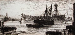
- Breaking up of the Agamemnon, No 1By Sir Francis Seymour Haden, R.A.Located in Storrs, CTEtching and drypoint. Schneiderman 133.v/xi. 7 3/4 x 16 3/8 (sheet 9 1/4 x 17 1/2). A rich impression with plate tone printed in black/brown in on antique cream wove paper. Signed in...Category
Mid-19th Century Old Masters Landscape Prints
MaterialsDrypoint, Etching
- AMERICABy John SpeedLocated in Santa Monica, CAIMPORTANT AMERICAN MAP - ONE OF THE FIRST TO SHOW CALIFORNIA as an ISLAND JOHN SPEED (1552-1629) AMERICA - With Those Known Parts In That Unknown Worlde (sic), 1626-(76) (Burden 217 iv/iv) Engraving, uncolored. Engraved by Abraham Goos and published by Thomas Basset and Richard Chiswell - 4th state of 4 in 1676 15 1/8 x 20 1/2” From “A Prospect of the Most Famous Parts of the World”. Generally good condition. A repaired split in lower centerfold. This is the most common version of this important map...Category
1620s Old Masters Landscape Prints
MaterialsEngraving
- The Deluge - JOSEPH MALLORD WILLIAM TURNER (1775 - 1851)By Joseph Mallord William TurnerLocated in Santa Monica, CA(after) JOSEPH MALLORD WILLIAM TURNER (1775 - 1851) THE DELUGE, 1828. Mezzotint, Engraved by I. P. Quilly after a painting by J. M.W. Turner R.A.. Image ...Category
1820s Old Masters Landscape Prints
MaterialsMezzotint
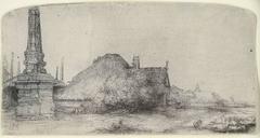
- COTTAGE AND OBELISK ON THE SPAARNDAMMERDIJKBy Rembrandt van RijnLocated in San Francisco, CAOriginal etching and drypoint printed in black ink on laid paper. A strong and dark 17th century/lifetime impression of Bartsch, Usticke and New Hollstein’s second and final stat...Category
18th Century and Earlier Old Masters Landscape Prints
MaterialsDrypoint, Etching
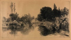
- Shere Mill PondBy Sir Francis Seymour Haden, R.A.Located in Missouri, MOShere Mill Pond, No. II (large plate). 1860. Etching and drypoint. Schneiderman 37.v/ix. 7 x 13 1/8 (sheet 10 3/4 x 16 3/8). This state is prior to publication in Études à l'Eau-Forte. Illustrated: Keppel The Golden Age of Engraving; Print Collector's Quarterly 1 (1911): 18; : Guichard, British Etchers, 1850-1940. A rich, brilliant proof with drypoint burr printed on white laid paper. Signed in pencil. ------------------------------------------------------------------------------------------- Shere Mill Pond, No. II was one of the most highly praised landscape prints of the etching revival. An impression was exhibited at the Royal Academy in 1861 under Haden’s pseudonym, H. Dean. Francis Seymour Haden used this anagram of his own name early in his career as an artist, in order to retain his anonymity and preserve his professional reputation as a surgeon. Biography: Sir Francis Seymour Haden (16 September 1818 - 1 June 1910), was an English surgeon, best known as an etcher. He was born in London, his father, Charles Thomas Haden, being a well-known doctor and lover of music. He was educated at Derby School, Christ's Hospital, and University College, London, and also studied at the Sorbonne, Paris, where he took his degree in 1840. He was admitted as a member of the College of Surgeons in London in 1842. In 1843-1844, with his friends Duval, Le Cannes and Colonel Guibout, he travelled in Italy and made his first sketches from nature. Haden attended no art school and had no art teachers, but between 1845 and 1848 he studied portfolios of prints belonging to a second-hand dealer named Love, who had a shop in Bunhill Row, the old Quaker quarter of London. Arranging the prints in chronological order, he studied the works of the great original engravers, Albrecht Dürer, Lucas van Leyden and Rembrandt. These studies, besides influencing his original work, led to his important monograph on the etched work of Rembrandt. By lecture and book, and with the aid of the memorable exhibition at the Burlington Fine Arts Club in 1877, he tried to give a true reflection of Rembrandt's work, giving a nobler idea of the master's mind by taking away from the list of his works many dull and unseemly plates that had long been included in the lists. His reasons were founded upon the results of a study of the master's works in chronological order, and are clearly expressed in his monograph, The Etched Work of Rembrandt critically reconsidered, privately printed in 1877, and in The Etched Work of Rembrandt True and False (1895). Haden's printmaking was invigorated by his much younger brother-in-law, James Whistler, at the Haden home in Sloane Street in 1855. A press was installed there and for a while Haden and Whistler collaborated on a series of etchings of the Thames. The relationship and project did not last. Haden followed the art of original etching with such vigour that he became not only the foremost British exponent of that art but brought about its revival in England. His strenuous efforts and perseverance, aided by the secretarial ability of Sir WR Drake, resulted in the foundation of the Royal Society of Painter-Etchers and Engravers. As president he ruled the society with a strong hand from its first beginnings in 1880. Notwithstanding his study of the old masters of his art, Haden's own plates were very individual, and are particularly noticeable for a fine original treatment of landscape subjects, free and open in line, clear and well divided in mass, and full of a noble and dignified style of his own. Even when working from a picture his personality dominates the plate, as for example in the large plate he etched after J.M.W. Turner's "Calais Pier," which is a classical example of what interpretative work can do in black and white. Of his original plates, more than 250 in number, one of the most notable was the large "Breaking up of the Agamemnon." An early plate, rare and most beautiful, is "Thames Fisherman". "Mytton Hall" is broad in treatment, and a fine rendering of a shady avenue of yew trees leading to an old manor-house in sunlight. "Sub Tegmine" was etched in Greenwich Park in 1859; and "Early Morning--Richmond", full of the poetry and freshness of the hour, was done, according to Haden, actually at sunrise. One of the rarest and most beautiful of his plates is "A By-Road in Tipperary"; "Combe Bottom" is another; and "Shere Mill Pond" (both the small study and the larger plate), "Sunset in Ireland," "Penton Hook," "Grim Spain" and "Evening Fishing, Longparish," are also notable examples of his genius. A catalogue of his works was begun by Sir William Drake and completed by Harrington in 1880. During later years Haden began to practise the sister art...Category
Late 19th Century Old Masters Landscape Prints
MaterialsEtching, Drypoint


Recently Viewed
View AllMore Ways To Browse
Gold Venice
Hand Colored Engraving
Antique Hand Colored Engravings
Antique Hand Colored Engraving
18th Century Engraving Framed
Death In Venice
18th Century Italian Landscape
18th Century Landscape Italy
18th Century Framed Art Print
18th Venice
18th Century Colored Engraving
Old Masters Venice
Venetian Colored
18th Century Italian Venice
Venice Engraving
Engravings Of Venice
18th Century City View
Venice Hand Colored