Items Similar to AMERICAE - Sive Novi Orbis, Nova Descriptio


Want more images or videos?
Request additional images or videos from the seller
1 of 8
Abraham OrteliusAMERICAE - Sive Novi Orbis, Nova Descriptio1587 (1603)
1587 (1603)
About the Item
ABRAHAM ORTELIUS (1527 - 1598)
AMERICAE SIVE NOVI ORBIS, NOVA DESCRIPTIO, 1587 (1603) (Van Den Broecke 11, Burden 64; Schwartz & Ehrenberg 69)
Engraving. A very good, well printed example with beautiful plate tone from the 3rd plate of 1587. With Latin text and "Promittis et Postell" at the 13th line from bottom being the edition of 1603 per Van den Broecke and Burden. Plate c. 14 1/4 x 19 1/4 inches, sheet 18 1/4 x 22 inches.
A very important and early map of the Western Hemisphere.
Uncolored, in good condition with good size margin. Uncolored maps reveal the beauty of engraving that is often obscured by the coloring. The coloring is frequently done many years or centuries after the printing of the map.
Just acquired. Photos with uneven lighting. Need to be re-shot.
- Creator:Abraham Ortelius (1527 - 1598, Dutch)
- Creation Year:1587 (1603)
- Dimensions:Height: 14.25 in (36.2 cm)Width: 19.25 in (48.9 cm)
- Medium:
- Movement & Style:
- Period:
- Condition:
- Gallery Location:Santa Monica, CA
- Reference Number:1stDibs: LU41138431632
About the Seller
5.0
Recognized Seller
These prestigious sellers are industry leaders and represent the highest echelon for item quality and design.
Platinum Seller
These expertly vetted sellers are 1stDibs' most experienced sellers and are rated highest by our customers.
Established in 1977
1stDibs seller since 2016
Typical response time: 1 hour
Associations
International Fine Print Dealers Association
- ShippingRetrieving quote...Ships From: Santa Monica, CA
- Return PolicyA return for this item may be initiated within 7 days of delivery.
More From This SellerView All
- AMERICABy John SpeedLocated in Santa Monica, CAIMPORTANT AMERICAN MAP - ONE OF THE FIRST TO SHOW CALIFORNIA as an ISLAND JOHN SPEED (1552-1629) AMERICA - With Those Known Parts In That Unknown Worlde (sic), 1626-(76) (Burden 217 iv/iv) Engraving, uncolored. Engraved by Abraham Goos and published by Thomas Basset and Richard Chiswell - 4th state of 4 in 1676 15 1/8 x 20 1/2” From “A Prospect of the Most Famous Parts of the World”. Generally good condition. A repaired split in lower centerfold. This is the most common version of this important map...Category
1620s Old Masters Landscape Prints
MaterialsEngraving
- The Deluge - JOSEPH MALLORD WILLIAM TURNER (1775 - 1851)By Joseph Mallord William TurnerLocated in Santa Monica, CA(after) JOSEPH MALLORD WILLIAM TURNER (1775 - 1851) THE DELUGE, 1828. Mezzotint, Engraved by I. P. Quilly after a painting by J. M.W. Turner R.A.. Image ...Category
1820s Old Masters Landscape Prints
MaterialsMezzotint
- New Map of the Terraqueous Globe - WORLD MAP - CALIFORNIA AS AN ISLANDBy Edward WellsLocated in Santa Monica, CAEDWARD WELLS (British 1667- 1727) A NEW MAP of the TERRAQUEOUS GLOBE - according to the latest Discoveries and most general Divisions of it into CONTINENTS and OCEANS, 1700-01 (Shirley 609) Engraved by Michael Burghers, Oxford. Hand-colored, Platemark 14 1/4 x 20 1/8 inches. Central cartouche flanked by figures representing the continents with dedication to William, Duke of Gloucester...Category
Early 1700s Old Masters Landscape Prints
MaterialsEngraving
- PERUBy Johannes JanssonLocated in Santa Monica, CAJOHANNES JANSSON (1588 - 1664) PERU, engraving with early coloring. Platemark 15 1/8 x 19 3/8 inches, sheet 17 x 20 1/2 A nice example of one of the earliest maps of Peru. From the ...Category
1630s Old Masters Landscape Prints
MaterialsEngraving
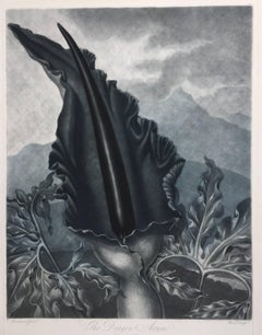
- THE DRAGON ARUMBy Dr. Robert John ThorntonLocated in Santa Monica, CADR. ROBERT JOHN THORNTON (circa 1768- 1837) THE DRAGON ARUM, 1801 (Dunthorne plate 161, pg. 250 i/iii; Nissen 1 955) Mezzotint printed in Payne's grey...Category
Early 1800s Old Masters Landscape Prints
MaterialsMezzotint
- WORLD MAP - Planisphaerium Terrestre Sive Terrarum Orbis... 1696By Carel AllardLocated in Santa Monica, CACAREL ALLARD (1648 – 1709) PLANISPHAERIUM TERRESTRE SIVE TERRARUM ORBIS… 1696 (Shirley 578) Engraving, 20 ½ x 23 ½”, sheet 21 x 24 1/8". A stunning double hemisphere World Map...Category
17th Century Old Masters Landscape Prints
MaterialsEngraving


You May Also Like
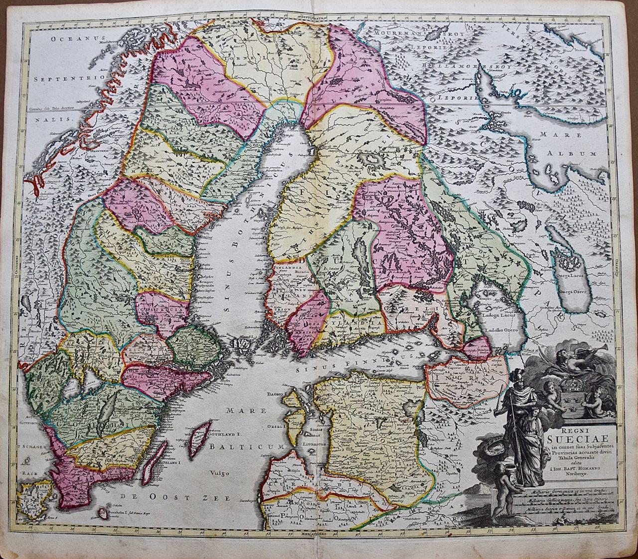
- Sweden and Adjacent Portions of Scandinavia: A Hand-colored 18th C. Homann MapBy Johann Baptist HomannLocated in Alamo, CAThis hand-colored copper-plate map of Sweden and adjacent portions of Scandinavia entitled "Regni Sueciae in Omnes suas Subjacentes Provincias accurate divisi Tabula Generalis" was c...Category
Early 18th Century Old Masters Landscape Prints
MaterialsEngraving
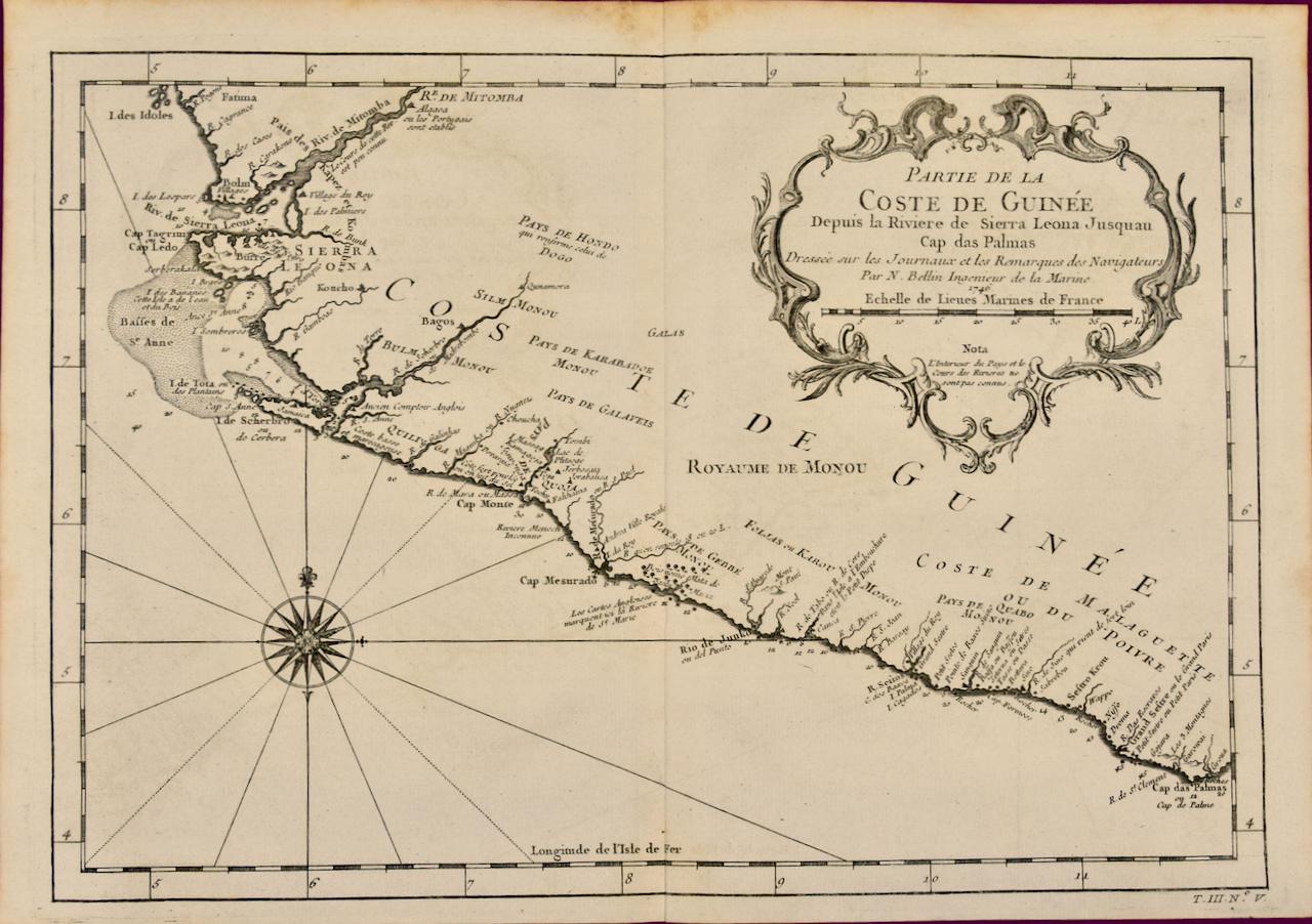
- West Coast of Africa; Guinea & Sierra Leone: Bellin 18th Century MapLocated in Alamo, CAThis is a Jacques Bellin copper-plate map entitled "Partie de la Coste de Guinee Dupuis la Riviere de Sierra Leona Jusquau Cap das Palmas", depicting the coast of Guinea and Sierra L...Category
1740s Old Masters Landscape Prints
MaterialsEngraving
- Danube River, Italy, Greece and Croatia: A Hand-colored 18th C. Homann MapBy Johann Baptist HomannLocated in Alamo, CA"Fluviorum in Europa principis Danubii" is a hand colored map of the region about the Danube river created by Johann Baptist Homann (1663-1724) in his 'Atlas Novus Terrarum', publish...Category
Early 18th Century Old Masters Landscape Prints
MaterialsEngraving
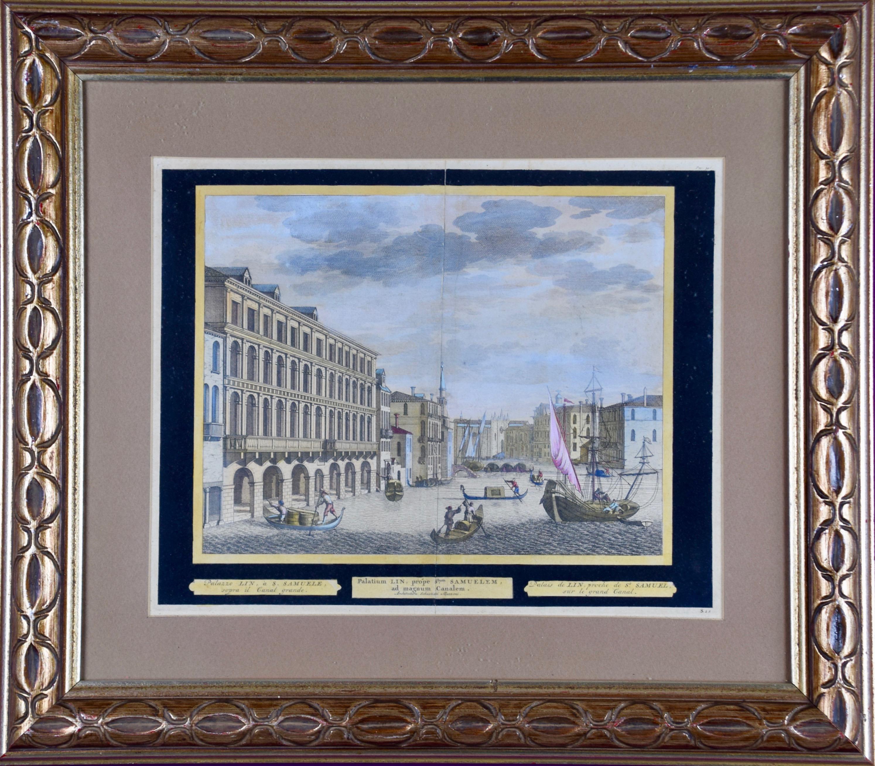
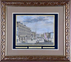
- View of Venice, including Gondolas, 18th Century Hand Colored EngravingBy Pieter Van Der AaLocated in Alamo, CAAn early 18th century hand colored engraving of a scene of the city of Venice, Italy entitled "Palazzo Lin, a. S. Samuele sopra il Canal Grande". It depicts Venetian architecture, wa...Category
1720s Old Masters Landscape Prints
MaterialsEngraving
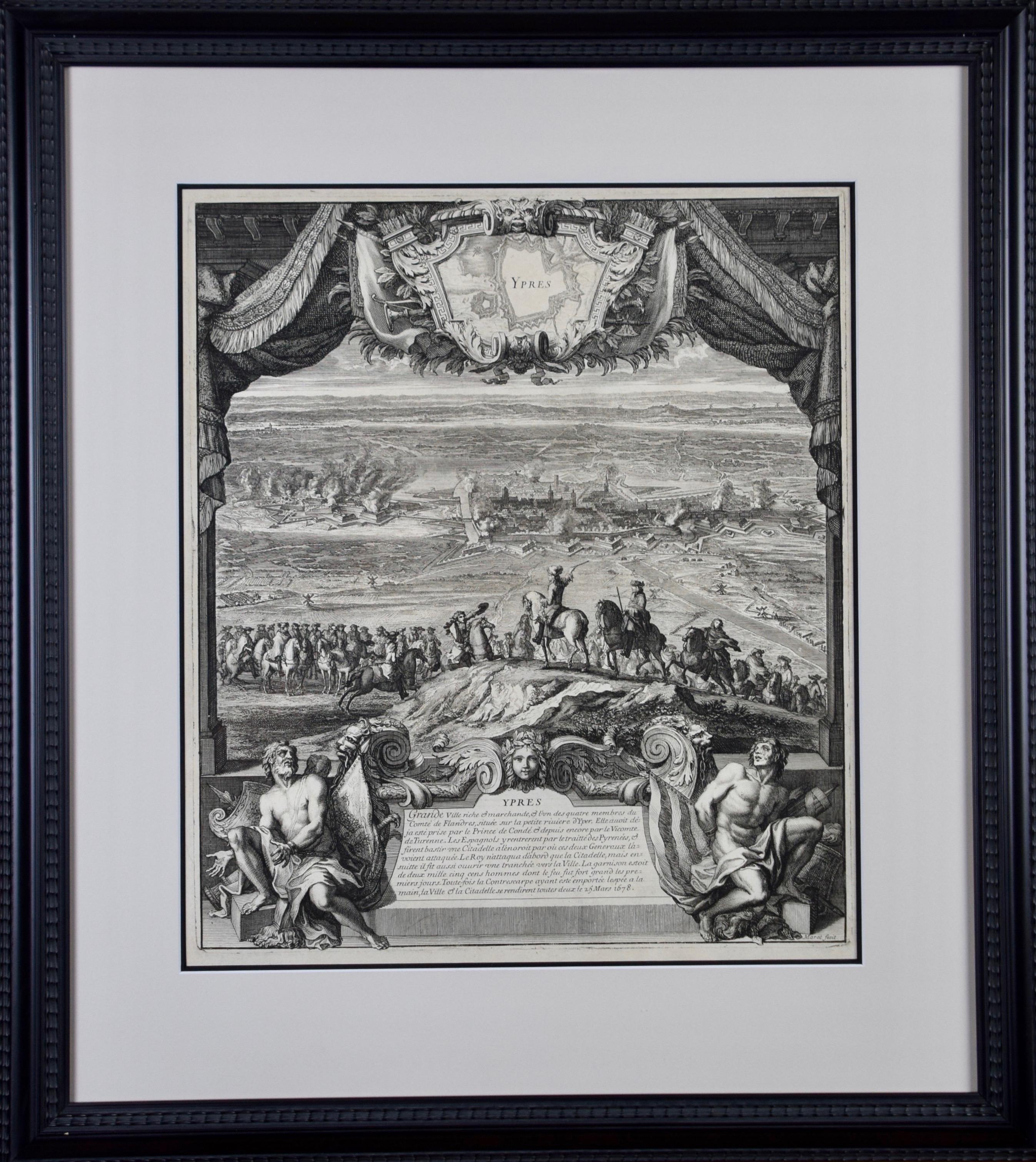
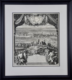
- Daniel Marot's The Siege of the Dutch Fortified City of Ypres by Louis XIVBy Daniel MarotLocated in Alamo, CA"Ypres, Grand Ville Riche & Marchande" is an engraving and etching by Daniel Marot (le Vieux) (1661–1752). It depicts a view of the siege of the city of Ypres and its citadel on the left in the Spanish Netherlands by Louis XIV's troops. This battle took place between March 18 and March 25, 1678, as part of the Franco-Dutch War. Marot illustrated in great detail (best appreciated with magnification) the French attack on the strong pentagonal citadel on the extreme left, which had been built recently in anticipation of a French attack. The trenches built by the French approaching the town are seen on the right. King Louis XIV can be seen in the foreground surveying the battle mounted on his white horse, surrounded by his officers and troops. The print is presented in an attractive ornate black wood frame with a cream-colored double mat with a black inner trim. It is glazed with plexiglas. The frame measures 25.38" x 22.63" x .88". The engraving, frame, mat and glazing are in excellent condition. Artist: Daniel Marot (1661–1752) was also called "Le Vieux". He was the son of the famous architect, Jean Marot. Marot had diverse interests and talents. In addition to his art, he designed garden projects, architectural ornaments, furniture, and even upholstery. Marot as a Huguenot protestant was forced to leave France in 1685 following the revocation of the Edict of Nantes. He emigrated to Holland, where he worked for William of Orange (an arch enemy of his former employer Louis XIV). Marot was largely responsible for the interiors of Williams palace at the Loo. In 1694 he went Britain as William had married Queen Mary and he had become King William III of England. He later returned to Holland in about 1698 and died in the Hague in 1752. He left a lasting legacy on the decorative arts in the Netherlands, where his grand version of the Louis XIV style remained popular into the 1730s. Historical Background: In October 1677, Mary Stuart, niece and possible successor of Charles II of England, married Louis XIV's arch enemy William III of Orange...Category
Late 17th Century Old Masters Landscape Prints
MaterialsEngraving, Etching
- Canterbury: An Original 16th C. Framed Hand-colored Map by Braun & HogenbergBy Franz HogenbergLocated in Alamo, CAThis is a framed 16th century map and city view of Canterbury, England entitled "Cantuarbury" by Braun & Hogenburg, from their famous landmark atlas of city views 'Civitates Orbis Terrarum' (Atlas of the Cities of the World), which was first published in Cologne, Germany in 1572. The map of Canterbury was first published in 1588. It depicts a detailed birdseye view of the completely walled and fortified city of Canterbury, with its cathedral the most prominent feature. The coat of arms of England, Canterbury, and the Archbishop of Canterbury are included. This beautifully hand-colored map is presented in a gold-colored wood frame with a beaded inner trim and a paprika-colored mat that highlights details in the map. The frame measures 18.75" high by 22.25" wide by 0.875" deep. There is a central vertical fold, as issued. The map is in excellent condition. Braun and Hogenberg's 'The Civitates Orbis Terrarum' was the second atlas of maps ever published and the first atlas of cities and towns of the world. It is one of the most important books published in the 16th century. Most of the maps in the atlas were engraved by Franz Hogenberg and the text, with its descriptions of the history and additional factual information of the cities, was written by a team of writers and edited by Georg Braun. The work contained 546 bird-eye views and map views of cities and towns from all over the world. It gave graphic representation of the main features of the illustrated cities and towns, including the buildings and streets. Although the ordinary buildings are stylized, the principal buildings are reproduced from actual drawings created on location. The principal landmarks and streets can still be recognized today. In addition, the maps often include the heraldic arms of the city, the nature of the surrounding countryside, the important rivers, streams and harbors, even depicting stone bridges, wooden pontoons, flat-bottomed ferries, ships and working boats, wharves and jetties, as well as land-based activities, including horsemen, pedestrians, wagons, coaches, and palanquins. Small vignettes are often included which illustrate the trade, occupations and habits of the local inhabitants, such as agriculture, paper-making and textiles, as well as local forms of punishment, such as gibbets, wheels, floggings etc. Large figures dressed in their local costume are often presented out of proportion in the foreground. The aim of the authors was to give as much information as possible in a pleasing visual form. They succeeded in creating maps that were both informative and decorative works of art. The atlas is a wonderful glimpse of life in medieval Europe. Georg Braun (1541-1622) was German Catholic...Category
16th Century Old Masters Landscape Prints
MaterialsEngraving


Recently Viewed
View AllMore Ways To Browse
Engravings Photo
Hemispheres Map
Antique Hemisphere Maps
Abraham Ortelius Holy Land
Akira Kurosaki
Campo Dei Fiori
Giovanni Korompay On Sale
Etam Cru
Harold L Doolittle
Orchard By David Harrison
Parc Monceau Harold Altman
Emile Boizot
David Roberts Edfou
Retro Breckenridge Ski Posters
Peter Milton On Sale
Peter Hort
Lilian May Miller
Jennifer Dickson